Königswartha geodata
Königswartha (Saxony) is a seat of a fourth-order administrative division; located in Germany in Europe/Berlin (GMT+2) time zone. With population of 3,767 people, there are 3429 cities with bigger population in this country. Compared to other cities in Germany, 63.4% of cities are located further ↓South; 99% of cities are located further ←West and 61.3% of cities have higher elevation than Königswartha. Note1


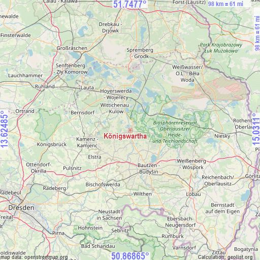
Königswartha GPS coordinates[2]
51° 18' 37.008" North, 14° 19' 40.692" East
| Map corner | latitude | longitude |
|---|---|---|
| Upper-left | 51.7477°, | 13.62485° |
| Center: | 51.31028°, | 14.32797° |
| Lower-right: | 50.86865°, | 15.0311° |
| Map W x H: | 97.7×97.7 km | = 60.7×60.7mi |
| max Lat: | 55.01917° ⇑36.6% North |
| Königswartha: | 51.31028° |
| min Lat: | ⇓63.4% South 47.40724° |
| min Long | Königswartha | max Long |
| 5.92978° | 14.32797° | 14.98853° |
| W 99%⇐ | ⇒1% E |
Elevation
Elevation of Königswartha is 144 m = 472 ft, and this is 105.1 m = 345 ft below average elevation for this country.
| Max E: |
1256 m = 4121 ft | 61.3% |
| Avg. | 249.1 m = 817 ft | |
| Königswartha | 144 m = 472 ft | |
Min E: |
-5 m = -16 ft | 38.7% |
See also: Germany elevation on elevation.city.
Geographical zone
Königswartha is located in North temperate zone (between Tropic of Cancer and the Arctic Circle). Distance of this North polar circle is 1696 km =1053.8 mi to North.| Distance of | km | miles | from Königswartha |
|---|---|---|---|
| North Pole | 4301.9 | 2673.1 | to North |
| Arctic Circle | 1696 | 1053.8 | to North |
| Tropic Cancer | 3099.2 | 1925.8 | to South |
| Equator | 5705.2 | 3545 | to South |


Nearby cities:
15 places around Königswartha: (largest is in red/bold)
• Crostwitz
9.9 km =6.2 mi,  216°
216°
• Großdubrau
11 km =6.8 mi,  124°
124°
• Göda
14.7 km =9.1 mi,  182°
182°
• Horka
7.3 km =4.5 mi, 224°
• Knappenrode
10.4 km =6.5 mi,  356°
356°
• Lohsa
9.5 km =5.9 mi,  31°
31°
• Nebelschütz
12.9 km =8 mi,  245°
245°
• Neschwitz
4.4 km =2.7 mi, 179°
• Oßling
12.6 km =7.8 mi,  296°
296°
• Panschwitz-Kuckau
12.4 km =7.7 mi,  226°
226°
• Puschwitz
6.4 km =4 mi,  196°
196°
• Radibor
8.8 km =5.5 mi,  146°
146°
• Räckelwitz
9.4 km =5.8 mi, 224°
• Uhyst
13.8 km =8.6 mi,  63°
63°
• Wittichenau
10.1 km =6.3 mi,  324°
324°
Sources, notices
• [Note1] Compared only with cities in Germany existing in our database
• [Src1] Map data: © OpenStreetMap contributors (CC-BY-SA)
• [Src2] Other city data from geonames.org with taken over terms of usage.
• [Src3] Geographical zone / Annual Mean Temperature by Robert A. Rohde @ Wikipedia
