Weilerswist geodata
Weilerswist (North Rhine-Westphalia) is a seat of a fourth-order administrative division; located in Germany in Europe/Berlin (GMT+2) time zone. With population of 16,321 people, there are 973 cities with bigger population in this country. Compared to other cities in Germany, 53.4% of cities are located further ↓South; 95.2% of cities are located further →East and 65% of cities have higher elevation than Weilerswist. Note1
Administrative division(s):
- Level 1: North Rhine-Westphalia
- Level 2: Regierungsbezirk Köln
- Level 3: Kreis Euskirchen
- Level 4: Weilerswist


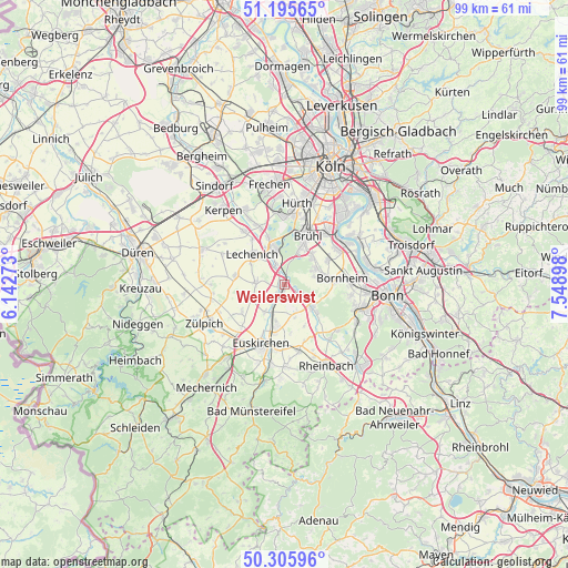
Weilerswist GPS coordinates[2]
50° 45' 10.512" North, 6° 50' 45.06" East
| Map corner | latitude | longitude |
|---|---|---|
| Upper-left | 51.19565°, | 6.14273° |
| Center: | 50.75292°, | 6.84585° |
| Lower-right: | 50.30596°, | 7.54898° |
| Map W x H: | 98.9×98.9 km | = 61.5×61.5mi |
| max Lat: | 55.01917° ⇑46.6% North |
| Weilerswist: | 50.75292° |
| min Lat: | ⇓53.4% South 47.40724° |
| min Long | Weilerswist | max Long |
| 5.92978° | 6.84585° | 14.98853° |
| W 4.8%⇐ | ⇒95.2% E |
Elevation
Elevation of Weilerswist is 120 m = 394 ft, and this is 129.1 m = 424 ft below average elevation for this country.
| Max E: |
1256 m = 4121 ft | 65% |
| Avg. | 249.1 m = 817 ft | |
| Weilerswist | 120 m = 394 ft | |
Min E: |
-5 m = -16 ft | 35% |
See also: Germany elevation on elevation.city.
Geographical zone
Weilerswist is located in North temperate zone (between Tropic of Cancer and the Arctic Circle). Distance of this North polar circle is 1758 km =1092.4 mi to North.| Distance of | km | miles | from Weilerswist |
|---|---|---|---|
| North Pole | 4363.9 | 2711.6 | to North |
| Arctic Circle | 1758 | 1092.4 | to North |
| Tropic Cancer | 3037.3 | 1887.3 | to South |
| Equator | 5643.2 | 3506.5 | to South |


Nearby cities:
15 places around Weilerswist: (largest is in red/bold)
• Alfter
12.2 km =7.6 mi,  100°
100°
• Bonn
17.7 km =11 mi, 96°
• Bornheim
10.3 km =6.4 mi,  83°
83°
• Brühl
9.5 km =5.9 mi,  26°
26°
• Erftstadt
7.8 km =4.8 mi,  332°
332°
• Euskirchen
11.1 km =6.9 mi,  201°
201°
• Hürth
13.2 km =8.2 mi,  6°
6°
• Kerpen
16.7 km =10.4 mi,  321°
321°
• Niederkassel
15.2 km =9.4 mi,  62°
62°
• Nörvenich
15.7 km =9.8 mi,  292°
292°
• Rheinbach
15.9 km =9.9 mi,  152°
152°
• Türnich
13.4 km =8.3 mi, 331°
• Vettweiß
17.4 km =10.8 mi,  262°
262°
• Wesseling
12.2 km =7.6 mi,  47°
47°
• Zulpich
15 km =9.3 mi,  244°
244°
Sources, notices
• [Note1] Compared only with cities in Germany existing in our database
• [Src1] Map data: © OpenStreetMap contributors (CC-BY-SA)
• [Src2] Other city data from geonames.org with taken over terms of usage.
• [Src3] Geographical zone / Annual Mean Temperature by Robert A. Rohde @ Wikipedia
