Postmünster geodata
Postmünster (Bavaria) is a seat of a fourth-order administrative division; located in Germany in Europe/Berlin (GMT+2) time zone. With population of 2,405 people, there are 4554 cities with bigger population in this country. Compared to other cities in Germany, 90% of cities are located further ↑North; 91.5% of cities are located further ←West and 75.9% of cities have lower elevation than Postmünster. Note1
Administrative division(s):
- Level 1: Bavaria
- Level 2: Lower Bavaria
- Level 3: Landkreis Rottal-Inn
- Level 4: Postmünster


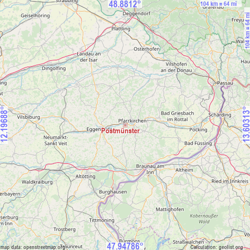
Postmünster GPS coordinates[2]
48° 25' 0.012" North, 12° 54' 0" East
| Map corner | latitude | longitude |
|---|---|---|
| Upper-left | 48.8812°, | 12.19688° |
| Center: | 48.41667°, | 12.9° |
| Lower-right: | 47.94786°, | 13.60313° |
| Map W x H: | 103.8×103.8 km | = 64.5×64.5mi |
| max Lat: | 55.01917° ⇑90% North |
| Postmünster: | 48.41667° |
| min Lat: | ⇓10% South 47.40724° |
| min Long | Postmünster | max Long |
| 5.92978° | 12.9° | 14.98853° |
| W 91.5%⇐ | ⇒8.5% E |
Elevation
Elevation of Postmünster is 405 m = 1329 ft, and this is 155.9 m = 511 ft above average elevation for this country.
| Max E: |
1256 m = 4121 ft | 24.1% |
| Postmünster | 405 m 1329 ft | |
| Avg. | 249.1 m = 817 ft | |
Min E: |
-5 m = -16 ft | 75.9% |
See also: Germany elevation on elevation.city.
Geographical zone
Postmünster is located in North temperate zone (between Tropic of Cancer and the Arctic Circle). Distance of this North polar circle is 2017.7 km =1253.7 mi to North.| Distance of | km | miles | from Postmünster |
|---|---|---|---|
| North Pole | 4623.6 | 2873 | to North |
| Arctic Circle | 2017.7 | 1253.7 | to North |
| Tropic Cancer | 2777.5 | 1725.9 | to South |
| Equator | 5383.4 | 3345.1 | to South |


Nearby cities:
15 places around Postmünster: (largest is in red/bold)
• Bad Birnbach
14.4 km =8.9 mi,  77°
77°
• Dietersburg
8.6 km =5.3 mi,  12°
12°
• Eggenfelden
10.6 km =6.6 mi,  263°
263°
• Falkenberg
13.5 km =8.4 mi,  291°
291°
• Hebertsfelden
5.8 km =3.6 mi, 258°
• Johanniskirchen
13.5 km =8.4 mi,  15°
15°
• Mitterskirchen
14.4 km =8.9 mi,  238°
238°
• Pfarrkirchen
3.3 km =2.1 mi,  58°
58°
• Reut
11.4 km =7.1 mi,  167°
167°
• Schönau
8.3 km =5.2 mi,  333°
333°
• Tann
11.4 km =7.1 mi,  182°
182°
• Triftern
8.2 km =5.1 mi,  107°
107°
• Wittibreut
11.7 km =7.3 mi,  146°
146°
• Wurmannsquick
11 km =6.8 mi,  230°
230°
• Zeilarn
13.6 km =8.5 mi,  198°
198°
Sources, notices
• [Note1] Compared only with cities in Germany existing in our database
• [Src1] Map data: © OpenStreetMap contributors (CC-BY-SA)
• [Src2] Other city data from geonames.org with taken over terms of usage.
• [Src3] Geographical zone / Annual Mean Temperature by Robert A. Rohde @ Wikipedia
