Trebbin geodata
Trebbin (Brandenburg) is a populated place; located in Germany in Europe/Berlin (GMT+2) time zone. With population of 9,199 people, there are 1754 cities with bigger population in this country. Compared to other cities in Germany, 74.3% of cities are located further ↓South; 93.8% of cities are located further ←West and 82.3% of cities have higher elevation than Trebbin. Note1


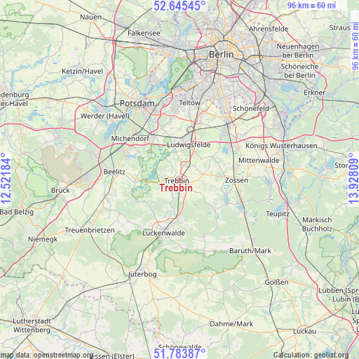
Trebbin GPS coordinates[2]
52° 13' 0.3" North, 13° 13' 29.856" East
| Map corner | latitude | longitude |
|---|---|---|
| Upper-left | 52.64545°, | 12.52184° |
| Center: | 52.21675°, | 13.22496° |
| Lower-right: | 51.78387°, | 13.92809° |
| Map W x H: | 95.8×95.8 km | = 59.5×59.5mi |
| max Lat: | 55.01917° ⇑25.7% North |
| Trebbin: | 52.21675° |
| min Lat: | ⇓74.3% South 47.40724° |
| min Long | Trebbin | max Long |
| 5.92978° | 13.22496° | 14.98853° |
| W 93.8%⇐ | ⇒6.2% E |
Elevation
Elevation of Trebbin is 41 m = 135 ft, and this is 208.1 m = 683 ft below average elevation for this country.
| Max E: |
1256 m = 4121 ft | 82.3% |
| Avg. | 249.1 m = 817 ft | |
| Trebbin | 41 m = 135 ft | |
Min E: |
-5 m = -16 ft | 17.7% |
See also: Germany elevation on elevation.city.
Geographical zone
Trebbin is located in North temperate zone (between Tropic of Cancer and the Arctic Circle). Distance of this North polar circle is 1595.2 km =991.2 mi to North.| Distance of | km | miles | from Trebbin |
|---|---|---|---|
| North Pole | 4201.1 | 2610.4 | to North |
| Arctic Circle | 1595.2 | 991.2 | to North |
| Tropic Cancer | 3200 | 1988.4 | to South |
| Equator | 5806 | 3607.7 | to South |


Nearby cities:
15 places around Trebbin: (largest is in red/bold)
• Am Mellensee
12.5 km =7.8 mi,  107°
107°
• Beelitz
17.4 km =10.8 mi,  277°
277°
• Großbeeren
16.8 km =10.4 mi,  20°
20°
• Kleinmachnow
21.2 km =13.2 mi,  0°
0°
• Luckenwalde
14.6 km =9.1 mi,  195°
195°
• Ludwigsfelde
9.8 km =6.1 mi,  11°
11°
• Michendorf
17.1 km =10.6 mi,  309°
309°
• Mittenwalde
21.9 km =13.6 mi,  77°
77°
• Potsdam
23 km =14.3 mi,  331°
331°
• Rangsdorf
15.6 km =9.7 mi,  57°
57°
• Sperenberg
12.7 km =7.9 mi,  131°
131°
• Stahnsdorf
18.5 km =11.5 mi,  358°
358°
• Teltow
20.9 km =13 mi, 6°
• Wannsee
23 km =14.3 mi,  348°
348°
• Zossen
15.3 km =9.5 mi,  90°
90°
Sources, notices
• [Note1] Compared only with cities in Germany existing in our database
• [Src1] Map data: © OpenStreetMap contributors (CC-BY-SA)
• [Src2] Other city data from geonames.org with taken over terms of usage.
• [Src3] Geographical zone / Annual Mean Temperature by Robert A. Rohde @ Wikipedia
