Luckenwalde geodata
Luckenwalde (Brandenburg) is a seat of a third-order administrative division; located in Germany in Europe/Berlin (GMT+2) time zone. With population of 21,616 people, there are 697 cities with bigger population in this country. Compared to other cities in Germany, 72.9% of cities are located further ↓South; 93.4% of cities are located further ←West and 78.3% of cities have higher elevation than Luckenwalde. Note1
Administrative division(s):
- Level 1: Brandenburg
- Level 3: Landkreis Teltow-Fläming
- Level 4: Luckenwalde


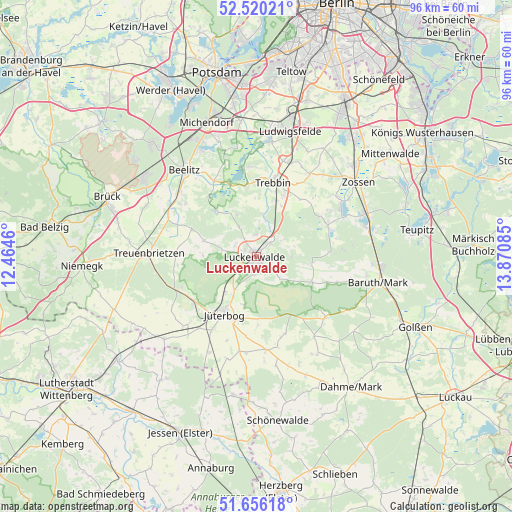
Luckenwalde GPS coordinates[2]
52° 5' 25.044" North, 13° 10' 3.792" East
| Map corner | latitude | longitude |
|---|---|---|
| Upper-left | 52.52021°, | 12.4646° |
| Center: | 52.09029°, | 13.16772° |
| Lower-right: | 51.65618°, | 13.87085° |
| Map W x H: | 96.1×96.1 km | = 59.7×59.7mi |
| max Lat: | 55.01917° ⇑27.1% North |
| Luckenwalde: | 52.09029° |
| min Lat: | ⇓72.9% South 47.40724° |
| min Long | Luckenwalde | max Long |
| 5.92978° | 13.16772° | 14.98853° |
| W 93.4%⇐ | ⇒6.6% E |
Elevation
Elevation of Luckenwalde is 52 m = 171 ft, and this is 197.1 m = 647 ft below average elevation for this country.
| Max E: |
1256 m = 4121 ft | 78.3% |
| Avg. | 249.1 m = 817 ft | |
| Luckenwalde | 52 m = 171 ft | |
Min E: |
-5 m = -16 ft | 21.7% |
See also: Germany elevation on elevation.city.
Geographical zone
Luckenwalde is located in North temperate zone (between Tropic of Cancer and the Arctic Circle). Distance of this North polar circle is 1609.3 km =1000 mi to North.| Distance of | km | miles | from Luckenwalde |
|---|---|---|---|
| North Pole | 4215.2 | 2619.2 | to North |
| Arctic Circle | 1609.3 | 1000 | to North |
| Tropic Cancer | 3186 | 1979.7 | to South |
| Equator | 5791.9 | 3598.9 | to South |


Nearby cities:
15 places around Luckenwalde: (largest is in red/bold)
• Am Mellensee
18.9 km =11.7 mi,  56°
56°
• Baruth
23.5 km =14.6 mi,  102°
102°
• Beelitz
21.2 km =13.2 mi,  320°
320°
• Borkheide
25.8 km =16 mi,  302°
302°
• Ihlow
27.4 km =17 mi,  154°
154°
• Jüterbog
12.1 km =7.5 mi,  209°
209°
• Linda
26.3 km =16.3 mi,  189°
189°
• Linthe
27.1 km =16.8 mi,  284°
284°
• Ludwigsfelde
24.4 km =15.2 mi,  13°
13°
• Michendorf
26.5 km =16.5 mi,  339°
339°
• Niedergörsdorf
17.5 km =10.9 mi,  225°
225°
• Sperenberg
14.6 km =9.1 mi,  67°
67°
• Trebbin
14.6 km =9.1 mi,  15°
15°
• Treuenbrietzen
20.2 km =12.6 mi,  272°
272°
• Zossen
23.7 km =14.7 mi,  53°
53°
Sources, notices
• [Note1] Compared only with cities in Germany existing in our database
• [Src1] Map data: © OpenStreetMap contributors (CC-BY-SA)
• [Src2] Other city data from geonames.org with taken over terms of usage.
• [Src3] Geographical zone / Annual Mean Temperature by Robert A. Rohde @ Wikipedia
