Pretzschendorf geodata
Pretzschendorf (Saxony) is a populated place; located in Germany in Europe/Berlin (GMT+2) time zone. With population of 4,440 people, there are 3068 cities with bigger population in this country. Compared to other cities in Germany, 55.6% of cities are located further ↓South; 95.9% of cities are located further ←West and 85.8% of cities have lower elevation than Pretzschendorf. Note1
Administrative division(s):
- Level 1: Saxony
- Level 3: Landkreis Sächsische Schweiz
- Level 4: Klingenberg


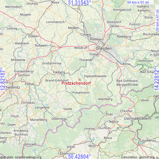
Pretzschendorf GPS coordinates[2]
50° 52' 25.86" North, 13° 31' 29.964" East
| Map corner | latitude | longitude |
|---|---|---|
| Upper-left | 51.31543°, | 12.82187° |
| Center: | 50.87385°, | 13.52499° |
| Lower-right: | 50.42804°, | 14.22812° |
| Map W x H: | 98.7×98.7 km | = 61.3×61.3mi |
| max Lat: | 55.01917° ⇑44.4% North |
| Pretzschendorf: | 50.87385° |
| min Lat: | ⇓55.6% South 47.40724° |
| min Long | Pretzschendorf | max Long |
| 5.92978° | 13.52499° | 14.98853° |
| W 95.9%⇐ | ⇒4.1% E |
Elevation
Elevation of Pretzschendorf is 475 m = 1558 ft, and this is 225.9 m = 741 ft above average elevation for this country.
| Max E: |
1256 m = 4121 ft | 14.2% |
| Pretzschendorf | 475 m 1558 ft | |
| Avg. | 249.1 m = 817 ft | |
Min E: |
-5 m = -16 ft | 85.8% |
See also: Germany elevation on elevation.city.
Geographical zone
Pretzschendorf is located in North temperate zone (between Tropic of Cancer and the Arctic Circle). Distance of this North polar circle is 1744.5 km =1084 mi to North.| Distance of | km | miles | from Pretzschendorf |
|---|---|---|---|
| North Pole | 4350.4 | 2703.2 | to North |
| Arctic Circle | 1744.5 | 1084 | to North |
| Tropic Cancer | 3050.7 | 1895.6 | to South |
| Equator | 5656.6 | 3514.8 | to South |


Nearby cities:
15 places around Pretzschendorf: (largest is in red/bold)
• Brand-Erbisdorf
14.2 km =8.8 mi,  266°
266°
• Dippoldiswalde
10.4 km =6.5 mi,  76°
76°
• Dorfchemnitz
13 km =8.1 mi,  203°
203°
• Dorfhain
7.2 km =4.5 mi,  23°
23°
• Frauenstein
8 km =5 mi,  173°
173°
• Freiberg
13.7 km =8.5 mi,  287°
287°
• Halsbrücke
14.9 km =9.3 mi,  304°
304°
• Lichtenberg
8.3 km =5.2 mi,  238°
238°
• Mulda
10.7 km =6.6 mi,  226°
226°
• Niederschöna
12.7 km =7.9 mi,  324°
324°
• Obercunnersdorf
5.4 km =3.4 mi,  27°
27°
• Rabenau
13.1 km =8.1 mi,  39°
39°
• Rechenberg-Bienenmühle
15.1 km =9.4 mi,  177°
177°
• Schmiedeberg
11.4 km =7.1 mi,  111°
111°
• Tharandt
13 km =8.1 mi, 17°
Sources, notices
• [Note1] Compared only with cities in Germany existing in our database
• [Src1] Map data: © OpenStreetMap contributors (CC-BY-SA)
• [Src2] Other city data from geonames.org with taken over terms of usage.
• [Src3] Geographical zone / Annual Mean Temperature by Robert A. Rohde @ Wikipedia
