Emmendingen geodata
Emmendingen (Baden-Württemberg) is a seat of a third-order administrative division; located in Germany in Europe/Berlin (GMT+2) time zone. With population of 27,383 people, there are 526 cities with bigger population in this country. Compared to other cities in Germany, 93.7% of cities are located further ↑North; 79.9% of cities are located further →East and 52.6% of cities have higher elevation than Emmendingen. Note1
Administrative division(s):
- Level 1: Baden-Württemberg
- Level 2: Freiburg Region
- Level 3: Landkreis Emmendingen
- Level 4: Emmendingen


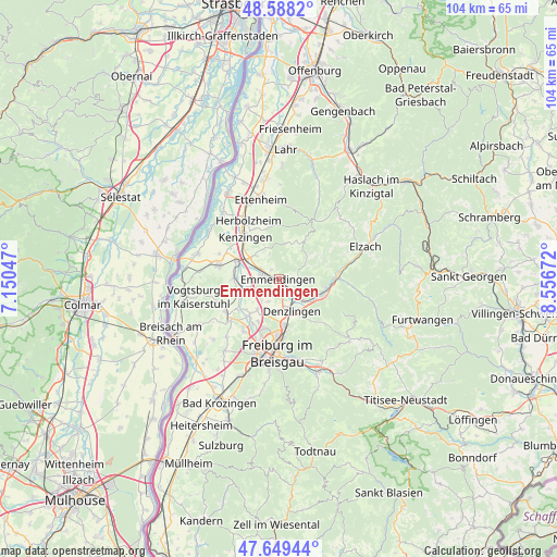
Emmendingen GPS coordinates[2]
48° 7' 15.456" North, 7° 51' 12.924" East
| Map corner | latitude | longitude |
|---|---|---|
| Upper-left | 48.5882°, | 7.15047° |
| Center: | 48.12096°, | 7.85359° |
| Lower-right: | 47.64944°, | 8.55672° |
| Map W x H: | 104.4×104.4 km | = 64.9×64.9mi |
| max Lat: | 55.01917° ⇑93.7% North |
| Emmendingen: | 48.12096° |
| min Lat: | ⇓6.3% South 47.40724° |
| min Long | Emmendingen | max Long |
| 5.92978° | 7.85359° | 14.98853° |
| W 20.1%⇐ | ⇒79.9% E |
Elevation
Elevation of Emmendingen is 207 m = 679 ft, and this is 42.1 m = 138 ft below average elevation for this country.
| Max E: |
1256 m = 4121 ft | 52.6% |
| Avg. | 249.1 m = 817 ft | |
| Emmendingen | 207 m = 679 ft | |
Min E: |
-5 m = -16 ft | 47.4% |
See also: Germany elevation on elevation.city.
Geographical zone
Emmendingen is located in North temperate zone (between Tropic of Cancer and the Arctic Circle). Distance of this North polar circle is 2050.6 km =1274.2 mi to North.| Distance of | km | miles | from Emmendingen |
|---|---|---|---|
| North Pole | 4656.5 | 2893.4 | to North |
| Arctic Circle | 2050.6 | 1274.2 | to North |
| Tropic Cancer | 2744.6 | 1705.4 | to South |
| Equator | 5350.5 | 3324.6 | to South |


Nearby cities:
15 places around Emmendingen: (largest is in red/bold)
• Bahlingen
8.4 km =5.2 mi,  269°
269°
• Buchheim
9.1 km =5.7 mi,  221°
221°
• Bötzingen
10.8 km =6.7 mi,  242°
242°
• Denzlingen
6.4 km =4 mi,  159°
159°
• Eichstetten
8.8 km =5.5 mi,  250°
250°
• Gundelfingen
8.8 km =5.5 mi,  174°
174°
• Gutach im Breisgau
9.6 km =6 mi,  92°
92°
• Heuweiler
8.6 km =5.3 mi, 156°
• Kenzingen
10.4 km =6.5 mi,  323°
323°
• Malterdingen
6.4 km =4 mi,  308°
308°
• Riegel
8.4 km =5.2 mi,  293°
293°
• Sexau
4.5 km =2.8 mi,  117°
117°
• Teningen
3.2 km =2 mi, 287°
• Vörstetten
6 km =3.7 mi,  182°
182°
• Waldkirch
8.6 km =5.3 mi,  108°
108°
Sources, notices
• [Note1] Compared only with cities in Germany existing in our database
• [Src1] Map data: © OpenStreetMap contributors (CC-BY-SA)
• [Src2] Other city data from geonames.org with taken over terms of usage.
• [Src3] Geographical zone / Annual Mean Temperature by Robert A. Rohde @ Wikipedia
