Herbolzheim geodata
Herbolzheim (Baden-Württemberg) is a populated place; located in Germany in Europe/Berlin (GMT+2) time zone. With population of 9,632 people, there are 1678 cities with bigger population in this country. Compared to other cities in Germany, 92.4% of cities are located further ↑North; 81.4% of cities are located further →East and 56.5% of cities have higher elevation than Herbolzheim. Note1
Administrative division(s):
- Level 1: Baden-Württemberg
- Level 2: Freiburg Region
- Level 3: Landkreis Emmendingen
- Level 4: Herbolzheim


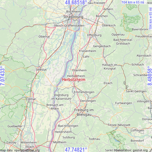
Herbolzheim GPS coordinates[2]
48° 13' 7.824" North, 7° 46' 38.856" East
| Map corner | latitude | longitude |
|---|---|---|
| Upper-left | 48.68518°, | 7.07433° |
| Center: | 48.21884°, | 7.77746° |
| Lower-right: | 47.74821°, | 8.48058° |
| Map W x H: | 104.2×104.2 km | = 64.7×64.7mi |
| max Lat: | 55.01917° ⇑92.4% North |
| Herbolzheim: | 48.21884° |
| min Lat: | ⇓7.6% South 47.40724° |
| min Long | Herbolzheim | max Long |
| 5.92978° | 7.77746° | 14.98853° |
| W 18.6%⇐ | ⇒81.4% E |
Elevation
Elevation of Herbolzheim is 178 m = 584 ft, and this is 71.1 m = 233 ft below average elevation for this country.
| Max E: |
1256 m = 4121 ft | 56.5% |
| Avg. | 249.1 m = 817 ft | |
| Herbolzheim | 178 m = 584 ft | |
Min E: |
-5 m = -16 ft | 43.5% |
See also: Germany elevation on elevation.city.
Geographical zone
Herbolzheim is located in North temperate zone (between Tropic of Cancer and the Arctic Circle). Distance of this North polar circle is 2039.7 km =1267.4 mi to North.| Distance of | km | miles | from Herbolzheim |
|---|---|---|---|
| North Pole | 4645.6 | 2886.6 | to North |
| Arctic Circle | 2039.7 | 1267.4 | to North |
| Tropic Cancer | 2755.5 | 1712.2 | to South |
| Equator | 5361.4 | 3331.4 | to South |


Nearby cities:
15 places around Herbolzheim: (largest is in red/bold)
• Endingen
10.3 km =6.4 mi,  213°
213°
• Ettenheim
5 km =3.1 mi,  31°
31°
• Forchheim
8.2 km =5.1 mi,  224°
224°
• Grafenhausen
7.3 km =4.5 mi,  353°
353°
• Kappel-Grafenhausen
7.3 km =4.5 mi, 353°
• Kenzingen
2.6 km =1.6 mi,  192°
192°
• Kippenheim
9.2 km =5.7 mi,  22°
22°
• Mahlberg
8 km =5 mi, 19°
• Malterdingen
6.9 km =4.3 mi,  174°
174°
• Riegel
7.8 km =4.8 mi,  195°
195°
• Ringsheim
3.2 km =2 mi,  1°
1°
• Rust
6.2 km =3.9 mi,  328°
328°
• Teningen
10.3 km =6.4 mi, 165°
• Weisweil
7.7 km =4.8 mi,  253°
253°
• Wyhl
11.2 km =7 mi,  238°
238°
Sources, notices
• [Note1] Compared only with cities in Germany existing in our database
• [Src1] Map data: © OpenStreetMap contributors (CC-BY-SA)
• [Src2] Other city data from geonames.org with taken over terms of usage.
• [Src3] Geographical zone / Annual Mean Temperature by Robert A. Rohde @ Wikipedia
