Budenheim geodata
Budenheim (Rheinland-Pfalz) is a seat of a fourth-order administrative division; located in Germany in Europe/Berlin (GMT+2) time zone. With population of 8,598 people, there are 1860 cities with bigger population in this country. Compared to other cities in Germany, 63.5% of cities are located further ↑North; 74.6% of cities are located further →East and 67.4% of cities have higher elevation than Budenheim. Note1
Administrative division(s):
- Level 1: Rheinland-Pfalz
- Level 3: Landkreis Mainz-Bingen
- Level 4: Budenheim


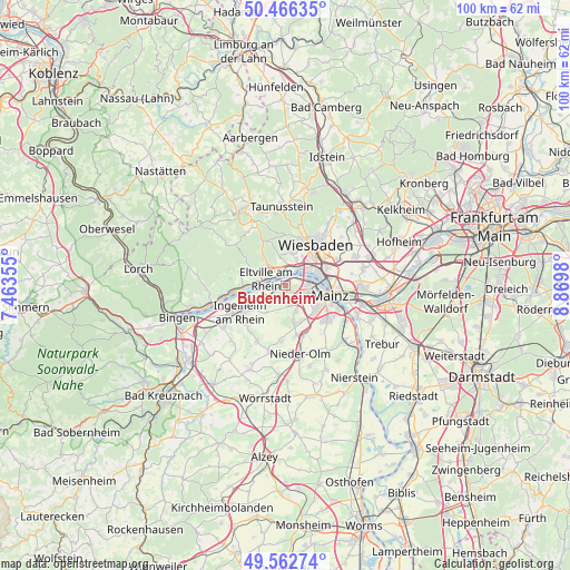
Budenheim GPS coordinates[2]
50° 1' 0.012" North, 8° 10' 0.012" East
| Map corner | latitude | longitude |
|---|---|---|
| Upper-left | 50.46635°, | 7.46355° |
| Center: | 50.01667°, | 8.16667° |
| Lower-right: | 49.56274°, | 8.8698° |
| Map W x H: | 100.5×100.5 km | = 62.4×62.4mi |
| max Lat: | 55.01917° ⇑63.5% North |
| Budenheim: | 50.01667° |
| min Lat: | ⇓36.5% South 47.40724° |
| min Long | Budenheim | max Long |
| 5.92978° | 8.16667° | 14.98853° |
| W 25.4%⇐ | ⇒74.6% E |
Elevation
Elevation of Budenheim is 105 m = 344 ft, and this is 144.1 m = 473 ft below average elevation for this country.
| Max E: |
1256 m = 4121 ft | 67.4% |
| Avg. | 249.1 m = 817 ft | |
| Budenheim | 105 m = 344 ft | |
Min E: |
-5 m = -16 ft | 32.6% |
See also: Germany elevation on elevation.city.
Geographical zone
Budenheim is located in North temperate zone (between Tropic of Cancer and the Arctic Circle). Distance of this North polar circle is 1839.8 km =1143.2 mi to North.| Distance of | km | miles | from Budenheim |
|---|---|---|---|
| North Pole | 4445.7 | 2762.4 | to North |
| Arctic Circle | 1839.8 | 1143.2 | to North |
| Tropic Cancer | 2955.4 | 1836.4 | to South |
| Equator | 5561.3 | 3455.6 | to South |


Nearby cities:
15 places around Budenheim: (largest is in red/bold)
• Eltville
3.8 km =2.4 mi,  290°
290°
• Essenheim
9.6 km =6 mi,  184°
184°
• Ingelheim am Rhein
9.2 km =5.7 mi,  236°
236°
• Kiedrich
6.3 km =3.9 mi, 293°
• Klein-Winternheim
9.3 km =5.8 mi,  159°
159°
• Mainz
8.8 km =5.5 mi,  114°
114°
• Nieder-Ingelheim
8 km =5 mi, 237°
• Nieder-Olm
12 km =7.5 mi,  166°
166°
• Ober-Olm
9 km =5.6 mi, 169°
• Schlangenbad
9.6 km =6 mi,  331°
331°
• Schwabenheim
11 km =6.8 mi,  207°
207°
• Stadecken-Elsheim
12 km =7.5 mi,  194°
194°
• Wackernheim
5.9 km =3.7 mi,  217°
217°
• Walluf
2.7 km =1.7 mi,  342°
342°
• Wiesbaden
9.4 km =5.8 mi,  38°
38°
Sources, notices
• [Note1] Compared only with cities in Germany existing in our database
• [Src1] Map data: © OpenStreetMap contributors (CC-BY-SA)
• [Src2] Other city data from geonames.org with taken over terms of usage.
• [Src3] Geographical zone / Annual Mean Temperature by Robert A. Rohde @ Wikipedia
