Mühltroff geodata
Mühltroff (Saxony) is a populated place; located in Germany in Europe/Berlin (GMT+2) time zone. With population of 1,949 people, there are 5139 cities with bigger population in this country. Compared to other cities in Germany, 52% of cities are located further ↑North; 80.7% of cities are located further ←West and 86.3% of cities have lower elevation than Mühltroff. Note1


Mühltroff GPS coordinates[2]
50° 32' 21.084" North, 11° 55' 41.808" East
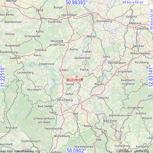
| Map corner | latitude | longitude |
|---|---|---|
| Upper-left | 50.98395°, | 11.22516° |
| Center: | 50.53919°, | 11.92828° |
| Lower-right: | 50.0902°, | 12.63141° |
| Map W x H: | 99.4×99.4 km | = 61.8×61.8mi |
| max Lat: | 55.01917° ⇑52% North |
| Mühltroff: | 50.53919° |
| min Lat: | ⇓48% South 47.40724° |
| min Long | Mühltroff | max Long |
| 5.92978° | 11.92828° | 14.98853° |
| W 80.7%⇐ | ⇒19.3% E |
Elevation
Elevation of Mühltroff is 480 m = 1575 ft, and this is 230.9 m = 758 ft above average elevation for this country.
| Max E: |
1256 m = 4121 ft | 13.7% |
| Mühltroff | 480 m 1575 ft | |
| Avg. | 249.1 m = 817 ft | |
Min E: |
-5 m = -16 ft | 86.3% |
See also: Germany elevation on elevation.city.
Geographical zone
Mühltroff is located in North temperate zone (between Tropic of Cancer and the Arctic Circle). Distance of this North polar circle is 1781.7 km =1107.1 mi to North.| Distance of | km | miles | from Mühltroff |
|---|---|---|---|
| North Pole | 4387.6 | 2726.3 | to North |
| Arctic Circle | 1781.7 | 1107.1 | to North |
| Tropic Cancer | 3013.5 | 1872.5 | to South |
| Equator | 5619.4 | 3491.7 | to South |


Nearby cities:
15 places around Mühltroff: (largest is in red/bold)
• Görkwitz
11.4 km =7.1 mi,  295°
295°
• Göschitz
11.3 km =7 mi,  337°
337°
• Kirschkau
7.9 km =4.9 mi, 338°
• Langenwolschendorf
10.9 km =6.8 mi,  9°
9°
• Löhma
9.7 km =6 mi,  326°
326°
• Mehltheuer
7.7 km =4.8 mi,  84°
84°
• Oettersdorf
10.4 km =6.5 mi,  310°
310°
• Pausa
6.8 km =4.2 mi,  45°
45°
• Pörmitz
11.7 km =7.3 mi,  317°
317°
• Reuth
8 km =5 mi,  164°
164°
• Schleiz
9.4 km =5.8 mi, 297°
• Syrau
10.7 km =6.6 mi,  87°
87°
• Tanna
7.1 km =4.4 mi,  225°
225°
• Tegau
13.1 km =8.1 mi, 340°
• Zeulenroda
13.2 km =8.2 mi,  17°
17°
Sources, notices
• [Note1] Compared only with cities in Germany existing in our database
• [Src1] Map data: © OpenStreetMap contributors (CC-BY-SA)
• [Src2] Other city data from geonames.org with taken over terms of usage.
• [Src3] Geographical zone / Annual Mean Temperature by Robert A. Rohde @ Wikipedia
