Pappenheim geodata
Pappenheim (Thuringia) is a populated place; located in Germany in Europe/Berlin (GMT+2) time zone. With population of 1,514 people, there are 5852 cities with bigger population in this country. Compared to other cities in Germany, 54% of cities are located further ↓South; 58.5% of cities are located further ←West and 83.4% of cities have lower elevation than Pappenheim. Note1
Administrative division(s):
- Level 1: Thuringia
- Level 3: Landkreis Schmalkalden-Meiningen
- Level 4: Floh-Seligenthal


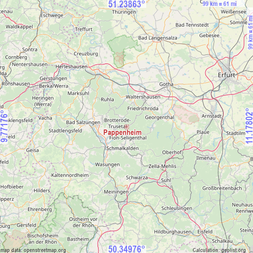
Pappenheim GPS coordinates[2]
50° 47' 46.716" North, 10° 28' 29.604" East
| Map corner | latitude | longitude |
|---|---|---|
| Upper-left | 51.23863°, | 9.77176° |
| Center: | 50.79631°, | 10.47489° |
| Lower-right: | 50.34976°, | 11.17802° |
| Map W x H: | 98.8×98.8 km | = 61.4×61.4mi |
| max Lat: | 55.01917° ⇑46% North |
| Pappenheim: | 50.79631° |
| min Lat: | ⇓54% South 47.40724° |
| min Long | Pappenheim | max Long |
| 5.92978° | 10.47489° | 14.98853° |
| W 58.5%⇐ | ⇒41.5% E |
Elevation
Elevation of Pappenheim is 457 m = 1499 ft, and this is 207.9 m = 682 ft above average elevation for this country.
| Max E: |
1256 m = 4121 ft | 16.6% |
| Pappenheim | 457 m 1499 ft | |
| Avg. | 249.1 m = 817 ft | |
Min E: |
-5 m = -16 ft | 83.4% |
See also: Germany elevation on elevation.city.
Geographical zone
Pappenheim is located in North temperate zone (between Tropic of Cancer and the Arctic Circle). Distance of this North polar circle is 1753.2 km =1089.4 mi to North.| Distance of | km | miles | from Pappenheim |
|---|---|---|---|
| North Pole | 4359 | 2708.6 | to North |
| Arctic Circle | 1753.2 | 1089.4 | to North |
| Tropic Cancer | 3042.1 | 1890.3 | to South |
| Equator | 5648 | 3509.5 | to South |


Nearby cities:
15 places around Pappenheim: (largest is in red/bold)
• Altersbach
11.5 km =7.1 mi,  158°
158°
• Bad Liebenstein
9 km =5.6 mi,  283°
283°
• Breitungen
11 km =6.8 mi,  250°
250°
• Brotterode
3.8 km =2.4 mi,  325°
325°
• Fambach
10.3 km =6.4 mi,  227°
227°
• Finsterbergen
9.1 km =5.7 mi,  62°
62°
• Friedrichroda
9.3 km =5.8 mi,  42°
42°
• Rotterode
10.9 km =6.8 mi,  149°
149°
• Schmalkalden
8.6 km =5.3 mi,  194°
194°
• Schweina
10.1 km =6.3 mi,  288°
288°
• Steinbach
8.8 km =5.5 mi,  297°
297°
• Tabarz
9.2 km =5.7 mi,  18°
18°
• Tambach-Dietharz
9.9 km =6.2 mi,  92°
92°
• Trusetal
4.3 km =2.7 mi, 250°
• Unterschönau
11.7 km =7.3 mi,  139°
139°
Sources, notices
• [Note1] Compared only with cities in Germany existing in our database
• [Src1] Map data: © OpenStreetMap contributors (CC-BY-SA)
• [Src2] Other city data from geonames.org with taken over terms of usage.
• [Src3] Geographical zone / Annual Mean Temperature by Robert A. Rohde @ Wikipedia
