Suderburg geodata
Suderburg (Lower Saxony) is a seat of a fourth-order administrative division; located in Germany in Europe/Berlin (GMT+2) time zone. With population of 4,778 people, there are 2909 cities with bigger population in this country. Compared to other cities in Germany, 81% of cities are located further ↓South; 58.2% of cities are located further ←West and 76.4% of cities have higher elevation than Suderburg. Note1


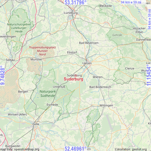
Suderburg GPS coordinates[2]
52° 53' 45.096" North, 10° 27' 5.076" East
| Map corner | latitude | longitude |
|---|---|---|
| Upper-left | 53.31796°, | 9.74828° |
| Center: | 52.89586°, | 10.45141° |
| Lower-right: | 52.46961°, | 11.15454° |
| Map W x H: | 94.3×94.3 km | = 58.6×58.6mi |
| max Lat: | 55.01917° ⇑19% North |
| Suderburg: | 52.89586° |
| min Lat: | ⇓81% South 47.40724° |
| min Long | Suderburg | max Long |
| 5.92978° | 10.45141° | 14.98853° |
| W 58.2%⇐ | ⇒41.8% E |
Elevation
Elevation of Suderburg is 58 m = 190 ft, and this is 191.1 m = 627 ft below average elevation for this country.
| Max E: |
1256 m = 4121 ft | 76.4% |
| Avg. | 249.1 m = 817 ft | |
| Suderburg | 58 m = 190 ft | |
Min E: |
-5 m = -16 ft | 23.6% |
See also: Germany elevation on elevation.city.
Geographical zone
Suderburg is located in North temperate zone (between Tropic of Cancer and the Arctic Circle). Distance of this North polar circle is 1519.7 km =944.3 mi to North.| Distance of | km | miles | from Suderburg |
|---|---|---|---|
| North Pole | 4125.6 | 2563.5 | to North |
| Arctic Circle | 1519.7 | 944.3 | to North |
| Tropic Cancer | 3275.5 | 2035.3 | to South |
| Equator | 5881.5 | 3654.6 | to South |


Nearby cities:
15 places around Suderburg: (largest is in red/bold)
• Bodenteich
17.1 km =10.6 mi,  115°
115°
• Ebstorf
14.8 km =9.2 mi,  351°
351°
• Eimke
12.1 km =7.5 mi,  310°
310°
• Emmendorf
15.8 km =9.8 mi,  28°
28°
• Gerdau
8.2 km =5.1 mi,  343°
343°
• Lüder
17.4 km =10.8 mi, 123°
• Obernholz
17.4 km =10.8 mi,  145°
145°
• Rätzlingen
17.4 km =10.8 mi,  59°
59°
• Schwienau
12.2 km =7.6 mi,  358°
358°
• Sprakensehl
14.6 km =9.1 mi,  169°
169°
• Stadensen
7.4 km =4.6 mi,  107°
107°
• Uelzen
10.7 km =6.6 mi,  43°
43°
• Unterlüß
12.4 km =7.7 mi,  236°
236°
• Wieren
14 km =8.7 mi,  94°
94°
• Wrestedt
8.3 km =5.2 mi,  83°
83°
Sources, notices
• [Note1] Compared only with cities in Germany existing in our database
• [Src1] Map data: © OpenStreetMap contributors (CC-BY-SA)
• [Src2] Other city data from geonames.org with taken over terms of usage.
• [Src3] Geographical zone / Annual Mean Temperature by Robert A. Rohde @ Wikipedia
