Bodenteich geodata
Bodenteich (Lower Saxony) is a seat of a fourth-order administrative division; located in Germany in Europe/Berlin (GMT+2) time zone. In our database, there are 11009 cities with bigger population. Compared to other cities in Germany, 80.6% of cities are located further ↓South; 62.1% of cities are located further ←West and 74.3% of cities have higher elevation than Bodenteich. Note1
Administrative division(s):
- Level 1: Lower Saxony
- Level 3: Landkreis Uelzen
- Level 4: Bad Bodenteich, Flecken


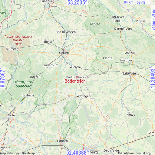
Bodenteich GPS coordinates[2]
52° 49' 50.772" North, 10° 40' 54.48" East
| Map corner | latitude | longitude |
|---|---|---|
| Upper-left | 53.2535°, | 9.97867° |
| Center: | 52.83077°, | 10.6818° |
| Lower-right: | 52.40388°, | 11.38493° |
| Map W x H: | 94.5×94.5 km | = 58.7×58.7mi |
| max Lat: | 55.01917° ⇑19.4% North |
| Bodenteich: | 52.83077° |
| min Lat: | ⇓80.6% South 47.40724° |
| min Long | Bodenteich | max Long |
| 5.92978° | 10.6818° | 14.98853° |
| W 62.1%⇐ | ⇒37.9% E |
Elevation
Elevation of Bodenteich is 66 m = 217 ft, and this is 183.1 m = 601 ft below average elevation for this country.
| Max E: |
1256 m = 4121 ft | 74.3% |
| Avg. | 249.1 m = 817 ft | |
| Bodenteich | 66 m = 217 ft | |
Min E: |
-5 m = -16 ft | 25.7% |
See also: Germany elevation on elevation.city.
Geographical zone
Bodenteich is located in North temperate zone (between Tropic of Cancer and the Arctic Circle). Distance of this North polar circle is 1526.9 km =948.8 mi to North.| Distance of | km | miles | from Bodenteich |
|---|---|---|---|
| North Pole | 4132.8 | 2568 | to North |
| Arctic Circle | 1526.9 | 948.8 | to North |
| Tropic Cancer | 3268.3 | 2030.8 | to South |
| Equator | 5874.2 | 3650.1 | to South |


Nearby cities:
15 places around Bodenteich: (largest is in red/bold)
• Dähre
15.5 km =9.6 mi,  103°
103°
• Hankensbüttel
12.2 km =7.6 mi,  206°
206°
• Lüder
2.7 km =1.7 mi,  203°
203°
• Obernholz
9.1 km =5.7 mi,  218°
218°
• Rätzlingen
16.1 km =10 mi,  358°
358°
• Schnega
15.6 km =9.7 mi,  64°
64°
• Soltendieck
7.2 km =4.5 mi,  48°
48°
• Sprakensehl
14.6 km =9.1 mi,  240°
240°
• Stadensen
9.8 km =6.1 mi,  300°
300°
• Suderburg
17.1 km =10.6 mi, 295°
• Suhlendorf
12.7 km =7.9 mi,  26°
26°
• Uelzen
17 km =10.6 mi,  331°
331°
• Wieren
6.3 km =3.9 mi,  345°
345°
• Wittingen
12.1 km =7.5 mi,  162°
162°
• Wrestedt
10.9 km =6.8 mi,  318°
318°
Sources, notices
• [Note1] Compared only with cities in Germany existing in our database
• [Src1] Map data: © OpenStreetMap contributors (CC-BY-SA)
• [Src2] Other city data from geonames.org with taken over terms of usage.
• [Src3] Geographical zone / Annual Mean Temperature by Robert A. Rohde @ Wikipedia
