Gerdau geodata
Gerdau (Lower Saxony) is a seat of a fourth-order administrative division; located in Germany in Europe/Berlin (GMT+2) time zone. With population of 1,614 people, there are 5663 cities with bigger population in this country. Compared to other cities in Germany, 81.5% of cities are located further ↓South; 57.3% of cities are located further ←West and 79.2% of cities have higher elevation than Gerdau. Note1


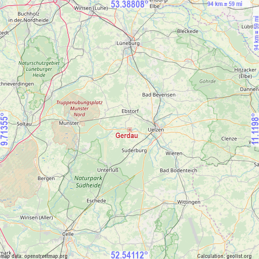
Gerdau GPS coordinates[2]
52° 58' 0.012" North, 10° 25' 0.012" East
| Map corner | latitude | longitude |
|---|---|---|
| Upper-left | 53.38808°, | 9.71355° |
| Center: | 52.96667°, | 10.41667° |
| Lower-right: | 52.54112°, | 11.1198° |
| Map W x H: | 94.2×94.2 km | = 58.5×58.5mi |
| max Lat: | 55.01917° ⇑18.5% North |
| Gerdau: | 52.96667° |
| min Lat: | ⇓81.5% South 47.40724° |
| min Long | Gerdau | max Long |
| 5.92978° | 10.41667° | 14.98853° |
| W 57.3%⇐ | ⇒42.7% E |
Elevation
Elevation of Gerdau is 49 m = 161 ft, and this is 200.1 m = 656 ft below average elevation for this country.
| Max E: |
1256 m = 4121 ft | 79.2% |
| Avg. | 249.1 m = 817 ft | |
| Gerdau | 49 m = 161 ft | |
Min E: |
-5 m = -16 ft | 20.8% |
See also: Germany elevation on elevation.city.
Geographical zone
Gerdau is located in North temperate zone (between Tropic of Cancer and the Arctic Circle). Distance of this North polar circle is 1511.8 km =939.4 mi to North.| Distance of | km | miles | from Gerdau |
|---|---|---|---|
| North Pole | 4117.7 | 2558.6 | to North |
| Arctic Circle | 1511.8 | 939.4 | to North |
| Tropic Cancer | 3283.4 | 2040.2 | to South |
| Equator | 5889.3 | 3659.4 | to South |


Nearby cities:
15 places around Gerdau: (largest is in red/bold)
• Bad Bevensen
16.7 km =10.4 mi,  41°
41°
• Barum
11.4 km =7.1 mi, 35°
• Ebstorf
6.8 km =4.2 mi,  0°
0°
• Eimke
6.9 km =4.3 mi,  269°
269°
• Emmendorf
11.6 km =7.2 mi,  58°
58°
• Hanstedt Eins
9.3 km =5.8 mi,  342°
342°
• Jelmstorf
16.6 km =10.3 mi,  25°
25°
• Natendorf
13.1 km =8.1 mi,  15°
15°
• Schwienau
4.7 km =2.9 mi, 23°
• Stadensen
13.8 km =8.6 mi,  137°
137°
• Suderburg
8.2 km =5.1 mi,  163°
163°
• Uelzen
9.7 km =6 mi,  90°
90°
• Unterlüß
16.7 km =10.4 mi,  208°
208°
• Wrestedt
12.7 km =7.9 mi,  123°
123°
• Wriedel
10.7 km =6.6 mi,  312°
312°
Sources, notices
• [Note1] Compared only with cities in Germany existing in our database
• [Src1] Map data: © OpenStreetMap contributors (CC-BY-SA)
• [Src2] Other city data from geonames.org with taken over terms of usage.
• [Src3] Geographical zone / Annual Mean Temperature by Robert A. Rohde @ Wikipedia
