Wieren geodata
Wieren (Lower Saxony) is a populated place; located in Germany in Europe/Berlin (GMT+2) time zone. With population of 2,666 people, there are 4262 cities with bigger population in this country. Compared to other cities in Germany, 81% of cities are located further ↓South; 61.8% of cities are located further ←West and 77% of cities have higher elevation than Wieren. Note1


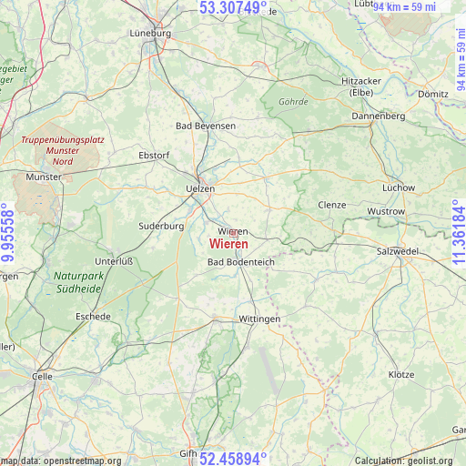
Wieren GPS coordinates[2]
52° 53' 7.044" North, 10° 39' 31.356" East
| Map corner | latitude | longitude |
|---|---|---|
| Upper-left | 53.30749°, | 9.95558° |
| Center: | 52.88529°, | 10.65871° |
| Lower-right: | 52.45894°, | 11.36184° |
| Map W x H: | 94.3×94.3 km | = 58.6×58.6mi |
| max Lat: | 55.01917° ⇑19% North |
| Wieren: | 52.88529° |
| min Lat: | ⇓81% South 47.40724° |
| min Long | Wieren | max Long |
| 5.92978° | 10.65871° | 14.98853° |
| W 61.8%⇐ | ⇒38.2% E |
Elevation
Elevation of Wieren is 56 m = 184 ft, and this is 193.1 m = 634 ft below average elevation for this country.
| Max E: |
1256 m = 4121 ft | 77% |
| Avg. | 249.1 m = 817 ft | |
| Wieren | 56 m = 184 ft | |
Min E: |
-5 m = -16 ft | 23% |
See also: Germany elevation on elevation.city.
Geographical zone
Wieren is located in North temperate zone (between Tropic of Cancer and the Arctic Circle). Distance of this North polar circle is 1520.9 km =945 mi to North.| Distance of | km | miles | from Wieren |
|---|---|---|---|
| North Pole | 4126.8 | 2564.3 | to North |
| Arctic Circle | 1520.9 | 945 | to North |
| Tropic Cancer | 3274.4 | 2034.6 | to South |
| Equator | 5880.3 | 3653.8 | to South |


Nearby cities:
15 places around Wieren: (largest is in red/bold)
• Bodenteich
6.3 km =3.9 mi,  165°
165°
• Emmendorf
16.3 km =10.1 mi,  337°
337°
• Lüder
8.5 km =5.3 mi,  176°
176°
• Obernholz
13.9 km =8.6 mi,  197°
197°
• Oetzen
14.9 km =9.3 mi,  4°
4°
• Rosche
12.9 km =8 mi,  28°
28°
• Rätzlingen
10.1 km =6.3 mi,  6°
6°
• Schnega
15.7 km =9.8 mi,  87°
87°
• Soltendieck
7 km =4.3 mi,  100°
100°
• Sprakensehl
17.3 km =10.7 mi,  220°
220°
• Stadensen
7 km =4.3 mi,  261°
261°
• Suderburg
14 km =8.7 mi,  274°
274°
• Suhlendorf
9 km =5.6 mi,  53°
53°
• Uelzen
11.1 km =6.9 mi,  323°
323°
• Wrestedt
6 km =3.7 mi,  290°
290°
Sources, notices
• [Note1] Compared only with cities in Germany existing in our database
• [Src1] Map data: © OpenStreetMap contributors (CC-BY-SA)
• [Src2] Other city data from geonames.org with taken over terms of usage.
• [Src3] Geographical zone / Annual Mean Temperature by Robert A. Rohde @ Wikipedia
