Steinau an der Straße geodata
Steinau an der Straße (Hesse) is a populated place; located in Germany in Europe/Berlin (GMT+2) time zone. With population of 11,302 people, there are 1461 cities with bigger population in this country. Compared to other cities in Germany, 56.5% of cities are located further ↑North; 58.4% of cities are located further →East and 57% of cities have higher elevation than Steinau an der Straße. Note1
Administrative division(s):
- Level 1: Hesse
- Level 2: Regierungsbezirk Darmstadt
- Level 3: Main-Kinzig-Kreis
- Level 4: Steinau an der Straße


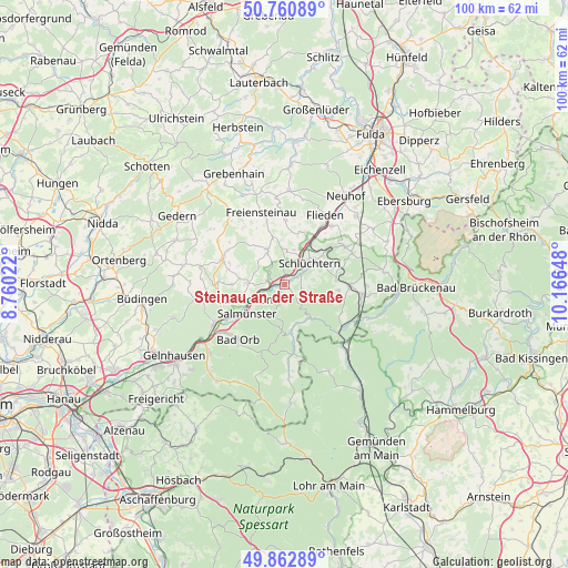
Steinau an der Straße GPS coordinates[2]
50° 18' 50.436" North, 9° 27' 48.06" East
| Map corner | latitude | longitude |
|---|---|---|
| Upper-left | 50.76089°, | 8.76022° |
| Center: | 50.31401°, | 9.46335° |
| Lower-right: | 49.86289°, | 10.16648° |
| Map W x H: | 99.8×99.8 km | = 62×62mi |
| max Lat: | 55.01917° ⇑56.5% North |
| Steinau an der Straße: | 50.31401° |
| min Lat: | ⇓43.5% South 47.40724° |
| min Long | Steinau an der | max Long |
| 5.92978° | 9.46335° | 14.98853° |
| W 41.6%⇐ | ⇒58.4% E |
Elevation
Elevation of Steinau an der Straße is 175 m = 574 ft, and this is 74.1 m = 243 ft below average elevation for this country.
| Max E: |
1256 m = 4121 ft | 57% |
| Avg. | 249.1 m = 817 ft | |
| Steinau an der Straße | 175 m = 574 ft | |
Min E: |
-5 m = -16 ft | 43% |
See also: Germany elevation on elevation.city.
Geographical zone
Steinau an der Straße is located in North temperate zone (between Tropic of Cancer and the Arctic Circle). Distance of this North polar circle is 1806.8 km =1122.7 mi to North.| Distance of | km | miles | from Steinau an der Straße |
|---|---|---|---|
| North Pole | 4412.7 | 2741.9 | to North |
| Arctic Circle | 1806.8 | 1122.7 | to North |
| Tropic Cancer | 2988.5 | 1857 | to South |
| Equator | 5594.4 | 3476.2 | to South |


Nearby cities:
15 places around Steinau an der Straße: (largest is in red/bold)
• Aura im Sinngrund
17.1 km =10.6 mi,  152°
152°
• Bad Orb
12.6 km =7.8 mi,  220°
220°
• Bad Soden-Salmünster
8.1 km =5 mi,  238°
238°
• Birstein
12.3 km =7.6 mi,  289°
289°
• Fellen
20.1 km =12.5 mi, 154°
• Flieden
14.2 km =8.8 mi,  30°
30°
• Freiensteinau
13.1 km =8.1 mi,  340°
340°
• Kalbach
18.5 km =11.5 mi,  57°
57°
• Kefenrod
18.2 km =11.3 mi,  280°
280°
• Mittelsinn
17.4 km =10.8 mi,  141°
141°
• Neuhof
18.9 km =11.7 mi,  35°
35°
• Obersinn
15.9 km =9.9 mi, 137°
• Schlüchtern
5.9 km =3.7 mi,  48°
48°
• Wächtersbach
13.6 km =8.5 mi, 241°
• Zeitlofs
15.9 km =9.9 mi,  111°
111°
Sources, notices
• [Note1] Compared only with cities in Germany existing in our database
• [Src1] Map data: © OpenStreetMap contributors (CC-BY-SA)
• [Src2] Other city data from geonames.org with taken over terms of usage.
• [Src3] Geographical zone / Annual Mean Temperature by Robert A. Rohde @ Wikipedia
