Flieden geodata
Flieden (Hesse) is a seat of a fourth-order administrative division; located in Germany in Europe/Berlin (GMT+2) time zone. With population of 8,843 people, there are 1815 cities with bigger population in this country. Compared to other cities in Germany, 54.2% of cities are located further ↑North; 56.8% of cities are located further →East and 61.5% of cities have lower elevation than Flieden. Note1
Administrative division(s):
- Level 1: Hesse
- Level 2: Regierungsbezirk Kassel
- Level 3: Landkreis Fulda
- Level 4: Flieden


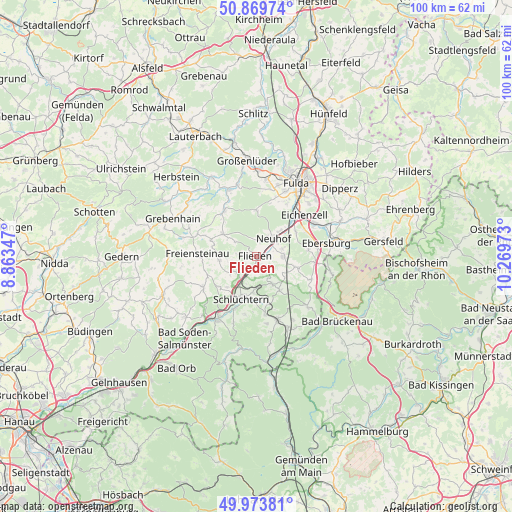
Flieden GPS coordinates[2]
50° 25' 26.004" North, 9° 33' 59.76" East
| Map corner | latitude | longitude |
|---|---|---|
| Upper-left | 50.86974°, | 8.86347° |
| Center: | 50.42389°, | 9.5666° |
| Lower-right: | 49.97381°, | 10.26973° |
| Map W x H: | 99.6×99.6 km | = 61.9×61.9mi |
| max Lat: | 55.01917° ⇑54.2% North |
| Flieden: | 50.42389° |
| min Lat: | ⇓45.8% South 47.40724° |
| min Long | Flieden | max Long |
| 5.92978° | 9.5666° | 14.98853° |
| W 43.2%⇐ | ⇒56.8% E |
Elevation
Elevation of Flieden is 299 m = 981 ft, and this is 49.9 m = 164 ft above average elevation for this country.
| Max E: |
1256 m = 4121 ft | 38.5% |
| Flieden | 299 m 981 ft | |
| Avg. | 249.1 m = 817 ft | |
Min E: |
-5 m = -16 ft | 61.5% |
See also: Germany elevation on elevation.city.
Geographical zone
Flieden is located in North temperate zone (between Tropic of Cancer and the Arctic Circle). Distance of this North polar circle is 1794.6 km =1115.1 mi to North.| Distance of | km | miles | from Flieden |
|---|---|---|---|
| North Pole | 4400.5 | 2734.3 | to North |
| Arctic Circle | 1794.6 | 1115.1 | to North |
| Tropic Cancer | 3000.7 | 1864.5 | to South |
| Equator | 5606.6 | 3483.8 | to South |


Nearby cities:
15 places around Flieden: (largest is in red/bold)
• Bad Brückenau
20.4 km =12.7 mi,  129°
129°
• Birstein
20.6 km =12.8 mi,  246°
246°
• Eichenzell
12.2 km =7.6 mi,  49°
49°
• Freiensteinau
11.6 km =7.2 mi,  270°
270°
• Fulda
16.1 km =10 mi,  28°
28°
• Grebenhain
17.7 km =11 mi,  294°
294°
• Großenlüder
18.8 km =11.7 mi,  354°
354°
• Hosenfeld
10.9 km =6.8 mi,  325°
325°
• Kalbach
8.5 km =5.3 mi,  104°
104°
• Künzell
17.1 km =10.6 mi,  38°
38°
• Motten
14.9 km =9.3 mi, 102°
• Neuhof
4.9 km =3 mi, 47°
• Schlüchtern
8.8 km =5.5 mi,  199°
199°
• Steinau an der Straße
14.2 km =8.8 mi,  210°
210°
• Zeitlofs
19.5 km =12.1 mi,  157°
157°
Sources, notices
• [Note1] Compared only with cities in Germany existing in our database
• [Src1] Map data: © OpenStreetMap contributors (CC-BY-SA)
• [Src2] Other city data from geonames.org with taken over terms of usage.
• [Src3] Geographical zone / Annual Mean Temperature by Robert A. Rohde @ Wikipedia
