Kalbach geodata
Kalbach (Hesse) is a seat of a fourth-order administrative division; located in Germany in Europe/Berlin (GMT+2) time zone. In our database, there are 11009 cities with bigger population. Compared to other cities in Germany, 54.5% of cities are located further ↑North; 54.7% of cities are located further →East and 78.7% of cities have lower elevation than Kalbach. Note1
Administrative division(s):
- Level 1: Hesse
- Level 2: Regierungsbezirk Kassel
- Level 3: Landkreis Fulda
- Level 4: Kalbach


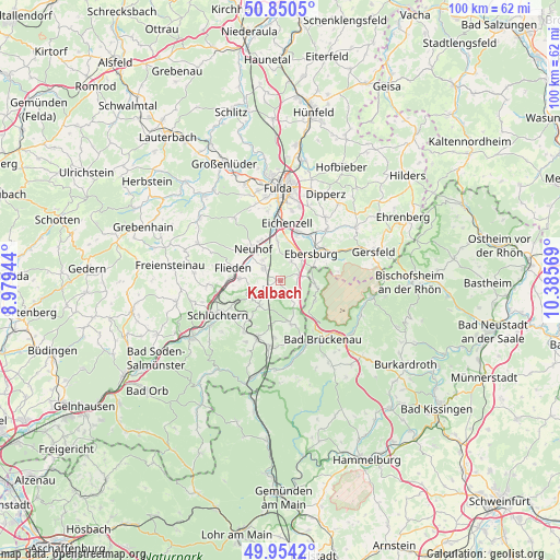
Kalbach GPS coordinates[2]
50° 24' 16.092" North, 9° 40' 57.216" East
| Map corner | latitude | longitude |
|---|---|---|
| Upper-left | 50.8505°, | 8.97944° |
| Center: | 50.40447°, | 9.68256° |
| Lower-right: | 49.9542°, | 10.38569° |
| Map W x H: | 99.7×99.7 km | = 62×62mi |
| max Lat: | 55.01917° ⇑54.5% North |
| Kalbach: | 50.40447° |
| min Lat: | ⇓45.5% South 47.40724° |
| min Long | Kalbach | max Long |
| 5.92978° | 9.68256° | 14.98853° |
| W 45.3%⇐ | ⇒54.7% E |
Elevation
Elevation of Kalbach is 424 m = 1391 ft, and this is 174.9 m = 574 ft above average elevation for this country.
| Max E: |
1256 m = 4121 ft | 21.3% |
| Kalbach | 424 m 1391 ft | |
| Avg. | 249.1 m = 817 ft | |
Min E: |
-5 m = -16 ft | 78.7% |
See also: Germany elevation on elevation.city.
Geographical zone
Kalbach is located in North temperate zone (between Tropic of Cancer and the Arctic Circle). Distance of this North polar circle is 1796.7 km =1116.4 mi to North.| Distance of | km | miles | from Kalbach |
|---|---|---|---|
| North Pole | 4402.6 | 2735.6 | to North |
| Arctic Circle | 1796.7 | 1116.4 | to North |
| Tropic Cancer | 2998.5 | 1863.2 | to South |
| Equator | 5604.5 | 3482.5 | to South |


Nearby cities:
15 places around Kalbach: (largest is in red/bold)
• Bad Brückenau
13.1 km =8.1 mi,  144°
144°
• Dipperz
17.4 km =10.8 mi,  27°
27°
• Eichenzell
10.2 km =6.3 mi,  5°
5°
• Flieden
8.5 km =5.3 mi,  284°
284°
• Fulda
16.4 km =10.2 mi,  358°
358°
• Gersfeld
17.2 km =10.7 mi,  72°
72°
• Künzell
15.7 km =9.8 mi, 9°
• Motten
6.5 km =4 mi,  98°
98°
• Neuhof
7.1 km =4.4 mi,  319°
319°
• Oberleichtersbach
15.8 km =9.8 mi,  148°
148°
• Poppenhausen
16.1 km =10 mi,  54°
54°
• Riedenberg
15.8 km =9.8 mi,  126°
126°
• Schlüchtern
12.7 km =7.9 mi,  241°
241°
• Wildflecken
16.5 km =10.3 mi, 100°
• Zeitlofs
15.9 km =9.9 mi,  182°
182°
Sources, notices
• [Note1] Compared only with cities in Germany existing in our database
• [Src1] Map data: © OpenStreetMap contributors (CC-BY-SA)
• [Src2] Other city data from geonames.org with taken over terms of usage.
• [Src3] Geographical zone / Annual Mean Temperature by Robert A. Rohde @ Wikipedia
