Berg geodata
Berg (Bavaria) is a seat of a fourth-order administrative division; located in Germany in Europe/Berlin (GMT+2) time zone. In our database, there are 11009 cities with bigger population. Compared to other cities in Germany, 95.8% of cities are located further ↑North; 72% of cities are located further ←West and 96.5% of cities have lower elevation than Berg. Note1
Administrative division(s):
- Level 1: Bavaria
- Level 2: Upper Bavaria
- Level 3: Landkreis Starnberg
- Level 4: Berg


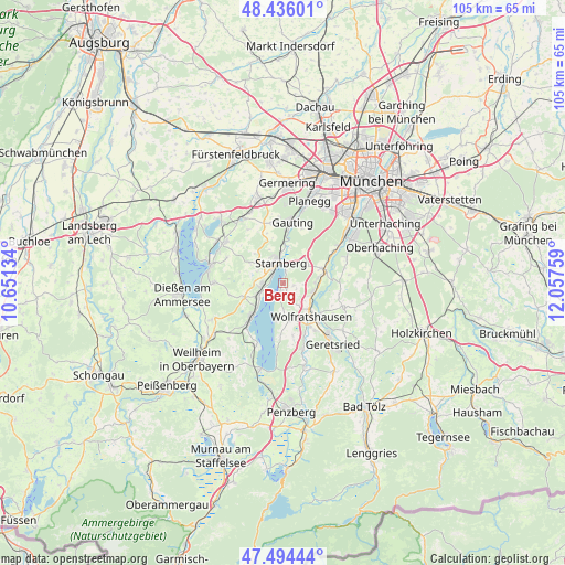
Berg GPS coordinates[2]
47° 58' 2.532" North, 11° 21' 16.056" East
| Map corner | latitude | longitude |
|---|---|---|
| Upper-left | 48.43601°, | 10.65134° |
| Center: | 47.96737°, | 11.35446° |
| Lower-right: | 47.49444°, | 12.05759° |
| Map W x H: | 104.7×104.7 km | = 65.1×65.1mi |
| max Lat: | 55.01917° ⇑95.8% North |
| Berg: | 47.96737° |
| min Lat: | ⇓4.2% South 47.40724° |
| min Long | Berg | max Long |
| 5.92978° | 11.35446° | 14.98853° |
| W 72%⇐ | ⇒28% E |
Elevation
Elevation of Berg is 642 m = 2106 ft, and this is 392.9 m = 1289 ft above average elevation for this country.
| Max E: |
1256 m = 4121 ft | 3.5% |
| Berg | 642 m 2106 ft | |
| Avg. | 249.1 m = 817 ft | |
Min E: |
-5 m = -16 ft | 96.5% |
See also: Germany elevation on elevation.city.
Geographical zone
Berg is located in North temperate zone (between Tropic of Cancer and the Arctic Circle). Distance of this North polar circle is 2067.7 km =1284.8 mi to North.| Distance of | km | miles | from Berg |
|---|---|---|---|
| North Pole | 4673.6 | 2904 | to North |
| Arctic Circle | 2067.7 | 1284.8 | to North |
| Tropic Cancer | 2727.6 | 1694.9 | to South |
| Equator | 5333.5 | 3314.1 | to South |


Nearby cities:
15 places around Berg: (largest is in red/bold)
• Andechs
12.8 km =8 mi,  273°
273°
• Baierbrunn
11.5 km =7.1 mi,  59°
59°
• Bernried
12.1 km =7.5 mi,  201°
201°
• Egling
12.3 km =7.6 mi,  113°
113°
• Feldafing
5.1 km =3.2 mi,  242°
242°
• Gauting
11.4 km =7.1 mi,  8°
8°
• Icking
6.2 km =3.9 mi, 108°
• Münsing
7.5 km =4.7 mi,  173°
173°
• Pöcking
4.1 km =2.5 mi, 268°
• Schäftlarn
8 km =5 mi,  71°
71°
• Seefeld
12.9 km =8 mi,  305°
305°
• Starnberg
3.9 km =2.4 mi,  348°
348°
• Straßlach-Dingharting
12.6 km =7.8 mi, 70°
• Tutzing
8.5 km =5.3 mi,  220°
220°
• Wolfratshausen
7.9 km =4.9 mi,  140°
140°
Sources, notices
• [Note1] Compared only with cities in Germany existing in our database
• [Src1] Map data: © OpenStreetMap contributors (CC-BY-SA)
• [Src2] Other city data from geonames.org with taken over terms of usage.
• [Src3] Geographical zone / Annual Mean Temperature by Robert A. Rohde @ Wikipedia
