Sohland geodata
Sohland (Saxony) is a populated place; located in Germany in Europe/Berlin (GMT+2) time zone. With population of 7,682 people, there are 2017 cities with bigger population in this country. Compared to other cities in Germany, 58.8% of cities are located further ↓South; 99.2% of cities are located further ←West and 64.2% of cities have lower elevation than Sohland. Note1


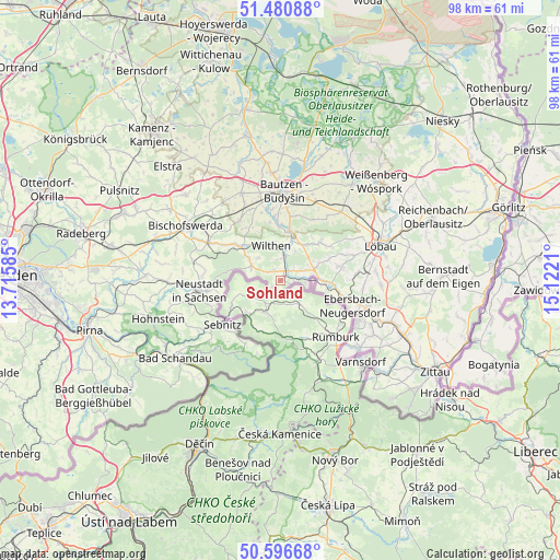
Sohland GPS coordinates[2]
51° 2' 27.204" North, 14° 25' 8.292" East
| Map corner | latitude | longitude |
|---|---|---|
| Upper-left | 51.48088°, | 13.71585° |
| Center: | 51.04089°, | 14.41897° |
| Lower-right: | 50.59668°, | 15.1221° |
| Map W x H: | 98.3×98.3 km | = 61.1×61.1mi |
| max Lat: | 55.01917° ⇑41.2% North |
| Sohland: | 51.04089° |
| min Lat: | ⇓58.8% South 47.40724° |
| min Long | Sohland | max Long |
| 5.92978° | 14.41897° | 14.98853° |
| W 99.2%⇐ | ⇒0.8% E |
Elevation
Elevation of Sohland is 316 m = 1037 ft, and this is 66.9 m = 219 ft above average elevation for this country.
| Max E: |
1256 m = 4121 ft | 35.8% |
| Sohland | 316 m 1037 ft | |
| Avg. | 249.1 m = 817 ft | |
Min E: |
-5 m = -16 ft | 64.2% |
See also: Germany elevation on elevation.city.
Geographical zone
Sohland is located in North temperate zone (between Tropic of Cancer and the Arctic Circle). Distance of this North polar circle is 1726 km =1072.5 mi to North.| Distance of | km | miles | from Sohland |
|---|---|---|---|
| North Pole | 4331.8 | 2691.7 | to North |
| Arctic Circle | 1726 | 1072.5 | to North |
| Tropic Cancer | 3069.3 | 1907.2 | to South |
| Equator | 5675.2 | 3526.4 | to South |


Nearby cities:
15 places around Sohland: (largest is in red/bold)
• Beiersdorf
9.1 km =5.7 mi,  66°
66°
• Crostau
5.5 km =3.4 mi,  27°
27°
• Cunewalde
9.5 km =5.9 mi,  46°
46°
• Ebersbach
12.3 km =7.6 mi,  107°
107°
• Friedersdorf
10.2 km =6.3 mi,  100°
100°
• Großpostwitz
9 km =5.6 mi,  9°
9°
• Kirschau
5.9 km =3.7 mi, 6°
• Neukirch/Lausitz
10 km =6.2 mi,  308°
308°
• Neusalza-Spremberg
8.2 km =5.1 mi,  91°
91°
• Obergurig
10.3 km =6.4 mi,  354°
354°
• Oppach
6.3 km =3.9 mi,  63°
63°
• Schirgiswalde
4 km =2.5 mi, 9°
• Schönbach
10.7 km =6.6 mi, 74°
• Steinigtwolmsdorf
5.7 km =3.5 mi,  295°
295°
• Wilthen
6.5 km =4 mi,  343°
343°
Sources, notices
• [Note1] Compared only with cities in Germany existing in our database
• [Src1] Map data: © OpenStreetMap contributors (CC-BY-SA)
• [Src2] Other city data from geonames.org with taken over terms of usage.
• [Src3] Geographical zone / Annual Mean Temperature by Robert A. Rohde @ Wikipedia
