Obergurig geodata
Obergurig (Saxony) is a seat of a fourth-order administrative division; located in Germany in Europe/Berlin (GMT+2) time zone. With population of 2,361 people, there are 4590 cities with bigger population in this country. Compared to other cities in Germany, 60.4% of cities are located further ↓South; 99.1% of cities are located further ←West and 53.2% of cities have lower elevation than Obergurig. Note1


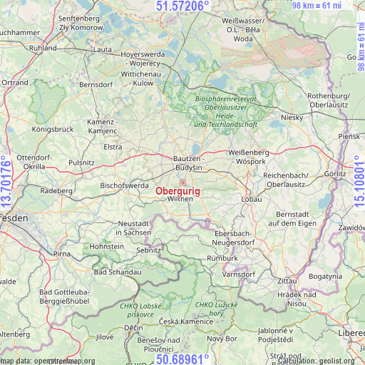
Obergurig GPS coordinates[2]
51° 7' 58.584" North, 14° 24' 17.568" East
| Map corner | latitude | longitude |
|---|---|---|
| Upper-left | 51.57206°, | 13.70176° |
| Center: | 51.13294°, | 14.40488° |
| Lower-right: | 50.68961°, | 15.10801° |
| Map W x H: | 98.1×98.1 km | = 61×61mi |
| max Lat: | 55.01917° ⇑39.6% North |
| Obergurig: | 51.13294° |
| min Lat: | ⇓60.4% South 47.40724° |
| min Long | Obergurig | max Long |
| 5.92978° | 14.40488° | 14.98853° |
| W 99.1%⇐ | ⇒0.90000000000001% E |
Elevation
Elevation of Obergurig is 248 m = 814 ft, and this is 1.1 m = 4 ft below average elevation for this country.
| Max E: |
1256 m = 4121 ft | 46.8% |
| Avg. | 249.1 m = 817 ft | |
| Obergurig | 248 m = 814 ft | |
Min E: |
-5 m = -16 ft | 53.2% |
See also: Germany elevation on elevation.city.
Geographical zone
Obergurig is located in North temperate zone (between Tropic of Cancer and the Arctic Circle). Distance of this North polar circle is 1715.7 km =1066.1 mi to North.| Distance of | km | miles | from Obergurig |
|---|---|---|---|
| North Pole | 4321.6 | 2685.3 | to North |
| Arctic Circle | 1715.7 | 1066.1 | to North |
| Tropic Cancer | 3079.5 | 1913.5 | to South |
| Equator | 5685.4 | 3532.7 | to South |


Nearby cities:
15 places around Obergurig: (largest is in red/bold)
• Bautzen
5.7 km =3.5 mi,  21°
21°
• Beiersdorf
11.4 km =7.1 mi,  125°
125°
• Crostau
6.4 km =4 mi,  146°
146°
• Cunewalde
8.6 km =5.3 mi,  115°
115°
• Demitz-Thumitz
11 km =6.8 mi,  274°
274°
• Großpostwitz
2.8 km =1.7 mi, 118°
• Göda
7.8 km =4.8 mi,  310°
310°
• Kirschau
4.7 km =2.9 mi,  159°
159°
• Kubschütz
7.6 km =4.7 mi,  60°
60°
• Neukirch/Lausitz
7.8 km =4.8 mi,  239°
239°
• Oppach
9.9 km =6.2 mi,  137°
137°
• Schirgiswalde
6.5 km =4 mi,  165°
165°
• Sohland
10.3 km =6.4 mi, 174°
• Steinigtwolmsdorf
8.8 km =5.5 mi,  208°
208°
• Wilthen
4 km =2.5 mi,  191°
191°
Sources, notices
• [Note1] Compared only with cities in Germany existing in our database
• [Src1] Map data: © OpenStreetMap contributors (CC-BY-SA)
• [Src2] Other city data from geonames.org with taken over terms of usage.
• [Src3] Geographical zone / Annual Mean Temperature by Robert A. Rohde @ Wikipedia
