Schirgiswalde geodata
Schirgiswalde (Saxony) is a populated place; located in Germany in Europe/Berlin (GMT+2) time zone. With population of 3,009 people, there are 3990 cities with bigger population in this country. Compared to other cities in Germany, 59.4% of cities are located further ↓South; 99.2% of cities are located further ←West and 57.9% of cities have lower elevation than Schirgiswalde. Note1
Administrative division(s):
- Level 1: Saxony
- Level 3: Landkreis Bautzen
- Level 4: Schirgiswalde-Kirschau


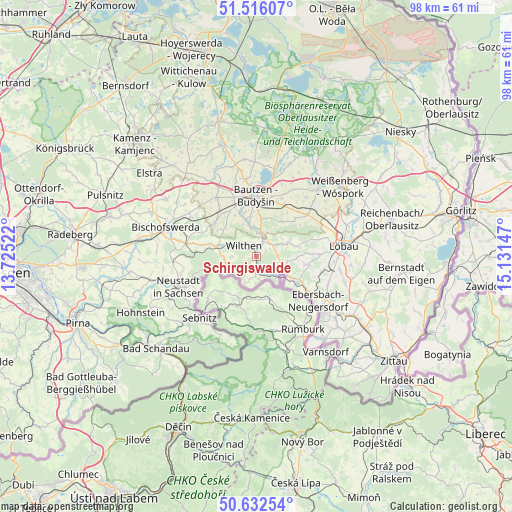
Schirgiswalde GPS coordinates[2]
51° 4' 35.076" North, 14° 25' 42.024" East
| Map corner | latitude | longitude |
|---|---|---|
| Upper-left | 51.51607°, | 13.72522° |
| Center: | 51.07641°, | 14.42834° |
| Lower-right: | 50.63254°, | 15.13147° |
| Map W x H: | 98.2×98.2 km | = 61×61mi |
| max Lat: | 55.01917° ⇑40.6% North |
| Schirgiswalde: | 51.07641° |
| min Lat: | ⇓59.4% South 47.40724° |
| min Long | Schirgiswalde | max Long |
| 5.92978° | 14.42834° | 14.98853° |
| W 99.2%⇐ | ⇒0.8% E |
Elevation
Elevation of Schirgiswalde is 278 m = 912 ft, and this is 28.9 m = 95 ft above average elevation for this country.
| Max E: |
1256 m = 4121 ft | 42.1% |
| Schirgiswalde | 278 m 912 ft | |
| Avg. | 249.1 m = 817 ft | |
Min E: |
-5 m = -16 ft | 57.9% |
See also: Germany elevation on elevation.city.
Geographical zone
Schirgiswalde is located in North temperate zone (between Tropic of Cancer and the Arctic Circle). Distance of this North polar circle is 1722 km =1070 mi to North.| Distance of | km | miles | from Schirgiswalde |
|---|---|---|---|
| North Pole | 4327.9 | 2689.2 | to North |
| Arctic Circle | 1722 | 1070 | to North |
| Tropic Cancer | 3073.2 | 1909.6 | to South |
| Equator | 5679.2 | 3528.9 | to South |


Nearby cities:
15 places around Schirgiswalde: (largest is in red/bold)
• Beiersdorf
7.7 km =4.8 mi,  91°
91°
• Crostau
2.1 km =1.3 mi,  64°
64°
• Cunewalde
6.7 km =4.2 mi,  66°
66°
• Friedersdorf
11 km =6.8 mi,  121°
121°
• Großpostwitz
5 km =3.1 mi,  9°
9°
• Kirschau
1.9 km =1.2 mi,  0°
0°
• Kubschütz
11.2 km =7 mi,  26°
26°
• Neukirch/Lausitz
8.7 km =5.4 mi,  285°
285°
• Neusalza-Spremberg
8.5 km =5.3 mi, 118°
• Obergurig
6.5 km =4 mi,  345°
345°
• Oppach
5.1 km =3.2 mi,  102°
102°
• Schönbach
9.7 km =6 mi, 96°
• Sohland
4 km =2.5 mi,  189°
189°
• Steinigtwolmsdorf
6 km =3.7 mi,  255°
255°
• Wilthen
3.4 km =2.1 mi,  313°
313°
Sources, notices
• [Note1] Compared only with cities in Germany existing in our database
• [Src1] Map data: © OpenStreetMap contributors (CC-BY-SA)
• [Src2] Other city data from geonames.org with taken over terms of usage.
• [Src3] Geographical zone / Annual Mean Temperature by Robert A. Rohde @ Wikipedia
