Großpostwitz geodata
Großpostwitz (Saxony) is a populated place; located in Germany in Europe/Berlin (GMT+2) time zone. With population of 3,116 people, there are 3905 cities with bigger population in this country. Compared to other cities in Germany, 60.2% of cities are located further ↓South; 99.2% of cities are located further ←West and 51.4% of cities have lower elevation than Großpostwitz. Note1


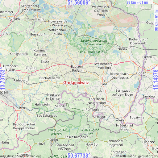
Großpostwitz GPS coordinates[2]
51° 7' 14.988" North, 14° 26' 26.34" East
| Map corner | latitude | longitude |
|---|---|---|
| Upper-left | 51.56006°, | 13.73753° |
| Center: | 51.12083°, | 14.44065° |
| Lower-right: | 50.67738°, | 15.14378° |
| Map W x H: | 98.1×98.1 km | = 61×61mi |
| max Lat: | 55.01917° ⇑39.8% North |
| Großpostwitz: | 51.12083° |
| min Lat: | ⇓60.2% South 47.40724° |
| min Long | Großpostwitz | max Long |
| 5.92978° | 14.44065° | 14.98853° |
| W 99.2%⇐ | ⇒0.8% E |
Elevation
Elevation of Großpostwitz is 236 m = 774 ft, and this is 13.1 m = 43 ft below average elevation for this country.
| Max E: |
1256 m = 4121 ft | 48.6% |
| Avg. | 249.1 m = 817 ft | |
| Großpostwitz | 236 m = 774 ft | |
Min E: |
-5 m = -16 ft | 51.4% |
See also: Germany elevation on elevation.city.
Geographical zone
Großpostwitz is located in North temperate zone (between Tropic of Cancer and the Arctic Circle). Distance of this North polar circle is 1717.1 km =1067 mi to North.| Distance of | km | miles | from Großpostwitz |
|---|---|---|---|
| North Pole | 4323 | 2686.2 | to North |
| Arctic Circle | 1717.1 | 1067 | to North |
| Tropic Cancer | 3078.2 | 1912.7 | to South |
| Equator | 5684.1 | 3531.9 | to South |


Nearby cities:
15 places around Großpostwitz: (largest is in red/bold)
• Bautzen
6.6 km =4.1 mi,  356°
356°
• Beiersdorf
8.6 km =5.3 mi,  127°
127°
• Crostau
4.2 km =2.6 mi,  165°
165°
• Cunewalde
5.8 km =3.6 mi,  113°
113°
• Göda
10.6 km =6.6 mi,  306°
306°
• Hochkirch
9.6 km =6 mi,  70°
70°
• Kirschau
3.2 km =2 mi,  195°
195°
• Kubschütz
6.6 km =4.1 mi,  39°
39°
• Neukirch/Lausitz
9.6 km =6 mi,  254°
254°
• Obergurig
2.8 km =1.7 mi,  298°
298°
• Oppach
7.3 km =4.5 mi,  145°
145°
• Schirgiswalde
5 km =3.1 mi,  189°
189°
• Sohland
9 km =5.6 mi, 189°
• Steinigtwolmsdorf
9.2 km =5.7 mi,  226°
226°
• Wilthen
4.2 km =2.6 mi, 232°
Sources, notices
• [Note1] Compared only with cities in Germany existing in our database
• [Src1] Map data: © OpenStreetMap contributors (CC-BY-SA)
• [Src2] Other city data from geonames.org with taken over terms of usage.
• [Src3] Geographical zone / Annual Mean Temperature by Robert A. Rohde @ Wikipedia
