Steinigtwolmsdorf geodata
Steinigtwolmsdorf (Saxony) is a seat of a fourth-order administrative division; located in Germany in Europe/Berlin (GMT+2) time zone. With population of 3,422 people, there are 3673 cities with bigger population in this country. Compared to other cities in Germany, 59.2% of cities are located further ↓South; 99% of cities are located further ←West and 75.7% of cities have lower elevation than Steinigtwolmsdorf. Note1


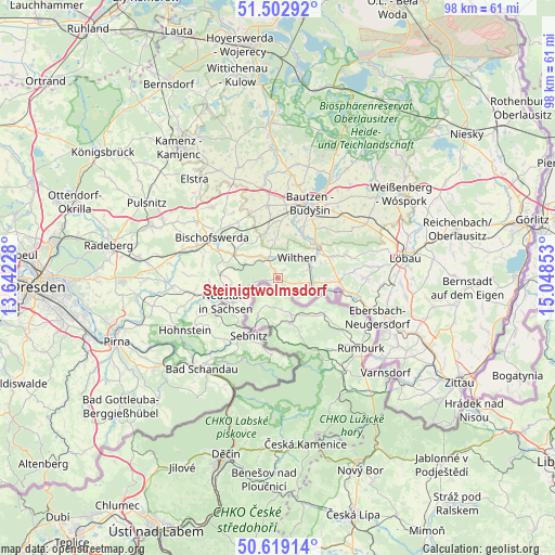
Steinigtwolmsdorf GPS coordinates[2]
51° 3' 47.304" North, 14° 20' 43.44" East
| Map corner | latitude | longitude |
|---|---|---|
| Upper-left | 51.50292°, | 13.64228° |
| Center: | 51.06314°, | 14.3454° |
| Lower-right: | 50.61914°, | 15.04853° |
| Map W x H: | 98.3×98.3 km | = 61.1×61.1mi |
| max Lat: | 55.01917° ⇑40.8% North |
| Steinigtwolmsdorf: | 51.06314° |
| min Lat: | ⇓59.2% South 47.40724° |
| min Long | Steinigtwolmsdo | max Long |
| 5.92978° | 14.3454° | 14.98853° |
| W 99%⇐ | ⇒1% E |
Elevation
Elevation of Steinigtwolmsdorf is 403 m = 1322 ft, and this is 153.9 m = 505 ft above average elevation for this country.
| Max E: |
1256 m = 4121 ft | 24.3% |
| Steinigtwolmsdorf | 403 m 1322 ft | |
| Avg. | 249.1 m = 817 ft | |
Min E: |
-5 m = -16 ft | 75.7% |
See also: Germany elevation on elevation.city.
Geographical zone
Steinigtwolmsdorf is located in North temperate zone (between Tropic of Cancer and the Arctic Circle). Distance of this North polar circle is 1723.5 km =1070.9 mi to North.| Distance of | km | miles | from Steinigtwolmsdorf |
|---|---|---|---|
| North Pole | 4329.4 | 2690.2 | to North |
| Arctic Circle | 1723.5 | 1070.9 | to North |
| Tropic Cancer | 3071.8 | 1908.7 | to South |
| Equator | 5677.7 | 3528 | to South |


Nearby cities:
15 places around Steinigtwolmsdorf: (largest is in red/bold)
• Berthelsdorf
8.8 km =5.5 mi,  258°
258°
• Crostau
8.1 km =5 mi,  72°
72°
• Cunewalde
12.6 km =7.8 mi, 71°
• Demitz-Thumitz
11.1 km =6.9 mi,  321°
321°
• Großpostwitz
9.2 km =5.7 mi,  46°
46°
• Göda
12.9 km =8 mi,  351°
351°
• Kirschau
6.7 km =4.2 mi,  60°
60°
• Neukirch/Lausitz
4.6 km =2.9 mi,  325°
325°
• Neustadt in Sachsen
9.7 km =6 mi,  246°
246°
• Obergurig
8.8 km =5.5 mi,  28°
28°
• Oppach
10.8 km =6.7 mi,  87°
87°
• Schirgiswalde
6 km =3.7 mi,  75°
75°
• Sebnitz
10.9 km =6.8 mi,  206°
206°
• Sohland
5.7 km =3.5 mi,  115°
115°
• Wilthen
5.1 km =3.2 mi,  41°
41°
Sources, notices
• [Note1] Compared only with cities in Germany existing in our database
• [Src1] Map data: © OpenStreetMap contributors (CC-BY-SA)
• [Src2] Other city data from geonames.org with taken over terms of usage.
• [Src3] Geographical zone / Annual Mean Temperature by Robert A. Rohde @ Wikipedia
