Wilthen geodata
Wilthen (Saxony) is a populated place; located in Germany in Europe/Berlin (GMT+2) time zone. With population of 6,304 people, there are 2364 cities with bigger population in this country. Compared to other cities in Germany, 59.8% of cities are located further ↓South; 99.1% of cities are located further ←West and 59.8% of cities have lower elevation than Wilthen. Note1


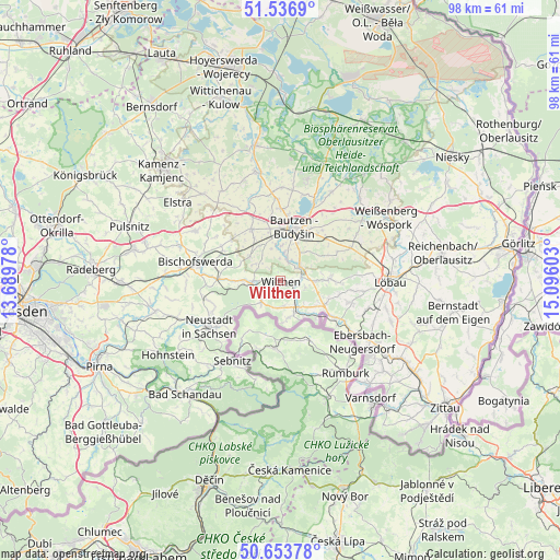
Wilthen GPS coordinates[2]
51° 5' 50.82" North, 14° 23' 34.44" East
| Map corner | latitude | longitude |
|---|---|---|
| Upper-left | 51.5369°, | 13.68978° |
| Center: | 51.09745°, | 14.3929° |
| Lower-right: | 50.65378°, | 15.09603° |
| Map W x H: | 98.2×98.2 km | = 61×61mi |
| max Lat: | 55.01917° ⇑40.2% North |
| Wilthen: | 51.09745° |
| min Lat: | ⇓59.8% South 47.40724° |
| min Long | Wilthen | max Long |
| 5.92978° | 14.3929° | 14.98853° |
| W 99.1%⇐ | ⇒0.90000000000001% E |
Elevation
Elevation of Wilthen is 289 m = 948 ft, and this is 39.9 m = 131 ft above average elevation for this country.
| Max E: |
1256 m = 4121 ft | 40.2% |
| Wilthen | 289 m 948 ft | |
| Avg. | 249.1 m = 817 ft | |
Min E: |
-5 m = -16 ft | 59.8% |
See also: Germany elevation on elevation.city.
Geographical zone
Wilthen is located in North temperate zone (between Tropic of Cancer and the Arctic Circle). Distance of this North polar circle is 1719.7 km =1068.6 mi to North.| Distance of | km | miles | from Wilthen |
|---|---|---|---|
| North Pole | 4325.6 | 2687.8 | to North |
| Arctic Circle | 1719.7 | 1068.6 | to North |
| Tropic Cancer | 3075.6 | 1911.1 | to South |
| Equator | 5681.5 | 3530.3 | to South |


Nearby cities:
15 places around Wilthen: (largest is in red/bold)
• Bautzen
9.7 km =6 mi,  17°
17°
• Beiersdorf
10.5 km =6.5 mi,  104°
104°
• Crostau
4.6 km =2.9 mi,  107°
107°
• Cunewalde
8.6 km =5.3 mi,  88°
88°
• Demitz-Thumitz
11.3 km =7 mi,  295°
295°
• Großpostwitz
4.2 km =2.6 mi,  52°
52°
• Göda
10.3 km =6.4 mi,  330°
330°
• Kirschau
2.5 km =1.6 mi, 100°
• Kubschütz
10.7 km =6.6 mi,  44°
44°
• Neukirch/Lausitz
5.9 km =3.7 mi,  269°
269°
• Obergurig
4 km =2.5 mi,  11°
11°
• Oppach
8.2 km =5.1 mi, 114°
• Schirgiswalde
3.4 km =2.1 mi,  133°
133°
• Sohland
6.5 km =4 mi,  163°
163°
• Steinigtwolmsdorf
5.1 km =3.2 mi,  221°
221°
Sources, notices
• [Note1] Compared only with cities in Germany existing in our database
• [Src1] Map data: © OpenStreetMap contributors (CC-BY-SA)
• [Src2] Other city data from geonames.org with taken over terms of usage.
• [Src3] Geographical zone / Annual Mean Temperature by Robert A. Rohde @ Wikipedia
