Schillig geodata
Schillig (Lower Saxony) is a populated place; located in Germany in Europe/Berlin (GMT+2) time zone. With population of 2,000 people, there are 5070 cities with bigger population in this country. Compared to other cities in Germany, 88.7% of cities are located further ↓South; 76.7% of cities are located further →East and 97.6% of cities have higher elevation than Schillig. Note1


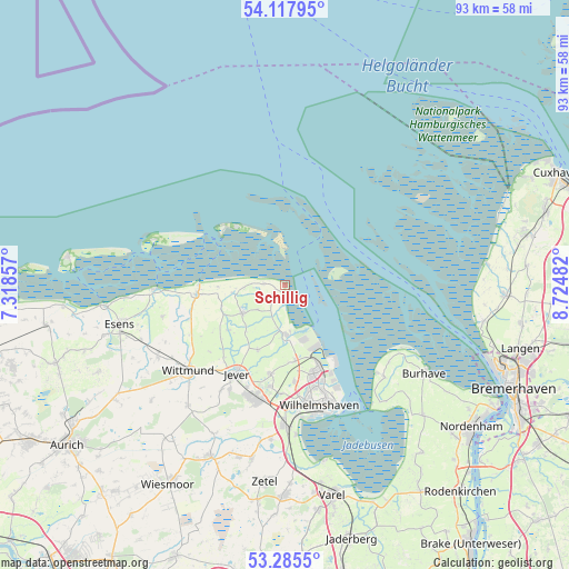
Schillig GPS coordinates[2]
53° 42' 13.608" North, 8° 1' 18.12" East
| Map corner | latitude | longitude |
|---|---|---|
| Upper-left | 54.11795°, | 7.31857° |
| Center: | 53.70378°, | 8.0217° |
| Lower-right: | 53.2855°, | 8.72482° |
| Map W x H: | 92.6×92.6 km | = 57.5×57.5mi |
| max Lat: | 55.01917° ⇑11.3% North |
| Schillig: | 53.70378° |
| min Lat: | ⇓88.7% South 47.40724° |
| min Long | Schillig | max Long |
| 5.92978° | 8.0217° | 14.98853° |
| W 23.3%⇐ | ⇒76.7% E |
Elevation
Elevation of Schillig is 3 m = 10 ft, and this is 246.1 m = 807 ft below average elevation for this country.
| Max E: |
1256 m = 4121 ft | 97.6% |
| Avg. | 249.1 m = 817 ft | |
| Schillig | 3 m = 10 ft | |
Min E: |
-5 m = -16 ft | 2.4% |
See also: Germany elevation on elevation.city.
Geographical zone
Schillig is located in North temperate zone (between Tropic of Cancer and the Arctic Circle). Distance of this North polar circle is 1429.9 km =888.5 mi to North.| Distance of | km | miles | from Schillig |
|---|---|---|---|
| North Pole | 4035.8 | 2507.7 | to North |
| Arctic Circle | 1429.9 | 888.5 | to North |
| Tropic Cancer | 3365.4 | 2091.2 | to South |
| Equator | 5971.3 | 3710.4 | to South |


Nearby cities:
15 places around Schillig: (largest is in red/bold)
• Butjadingen
27 km =16.8 mi,  130°
130°
• Carolinensiel
14.6 km =9.1 mi,  264°
264°
• Dunum
27.1 km =16.8 mi,  244°
244°
• Fedderwarden
15.9 km =9.9 mi,  174°
174°
• Jever
16.6 km =10.3 mi,  209°
209°
• Neuharlingersiel
21 km =13 mi,  268°
268°
• Sande
22.1 km =13.7 mi,  181°
181°
• Schortens
19.5 km =12.1 mi,  194°
194°
• Sillenstede
14.6 km =9.1 mi, 189°
• Spiekeroog
22.7 km =14.1 mi,  288°
288°
• Stedesdorf
24.7 km =15.3 mi,  251°
251°
• Wangerooge
12.5 km =7.8 mi,  320°
320°
• Werdum
20.6 km =12.8 mi, 255°
• Wilhelmshaven
20.2 km =12.6 mi,  162°
162°
• Wittmund
21.4 km =13.3 mi,  228°
228°
Sources, notices
• [Note1] Compared only with cities in Germany existing in our database
• [Src1] Map data: © OpenStreetMap contributors (CC-BY-SA)
• [Src2] Other city data from geonames.org with taken over terms of usage.
• [Src3] Geographical zone / Annual Mean Temperature by Robert A. Rohde @ Wikipedia
