Seyda geodata
Seyda (Saxony-Anhalt) is a populated place; located in Germany in Europe/Berlin (GMT+2) time zone. With population of 1,043 people, there are 7036 cities with bigger population in this country. Compared to other cities in Germany, 70.8% of cities are located further ↓South; 91.5% of cities are located further ←West and 71.8% of cities have higher elevation than Seyda. Note1
Administrative division(s):
- Level 1: Saxony-Anhalt
- Level 3: Landkreis Wittenberg
- Level 4: Jessen (Elster)


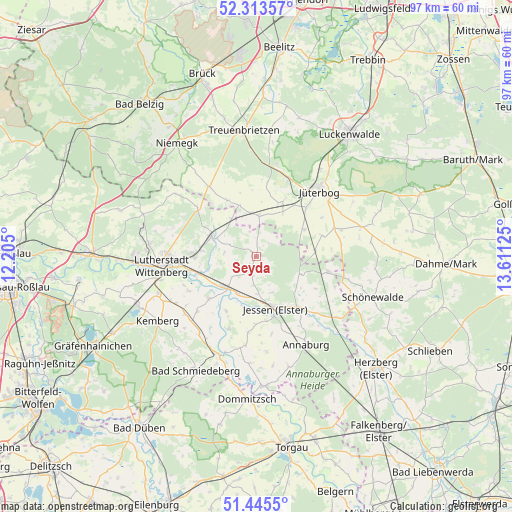
Seyda GPS coordinates[2]
51° 52' 53.868" North, 12° 54' 29.232" East
| Map corner | latitude | longitude |
|---|---|---|
| Upper-left | 52.31357°, | 12.205° |
| Center: | 51.88163°, | 12.90812° |
| Lower-right: | 51.4455°, | 13.61125° |
| Map W x H: | 96.5×96.5 km | = 60×60mi |
| max Lat: | 55.01917° ⇑29.2% North |
| Seyda: | 51.88163° |
| min Lat: | ⇓70.8% South 47.40724° |
| min Long | Seyda | max Long |
| 5.92978° | 12.90812° | 14.98853° |
| W 91.5%⇐ | ⇒8.5% E |
Elevation
Elevation of Seyda is 79 m = 259 ft, and this is 170.1 m = 558 ft below average elevation for this country.
| Max E: |
1256 m = 4121 ft | 71.8% |
| Avg. | 249.1 m = 817 ft | |
| Seyda | 79 m = 259 ft | |
Min E: |
-5 m = -16 ft | 28.2% |
See also: Germany elevation on elevation.city.
Geographical zone
Seyda is located in North temperate zone (between Tropic of Cancer and the Arctic Circle). Distance of this North polar circle is 1632.5 km =1014.4 mi to North.| Distance of | km | miles | from Seyda |
|---|---|---|---|
| North Pole | 4238.4 | 2633.6 | to North |
| Arctic Circle | 1632.5 | 1014.4 | to North |
| Tropic Cancer | 3162.8 | 1965.3 | to South |
| Equator | 5768.7 | 3584.5 | to South |


Nearby cities:
15 places around Seyda: (largest is in red/bold)
• Abtsdorf
12.6 km =7.8 mi,  274°
274°
• Bülzig
10.6 km =6.6 mi,  277°
277°
• Dabrun
14.7 km =9.1 mi,  248°
248°
• Elster
8.1 km =5 mi,  225°
225°
• Elstervorstadt
15 km =9.3 mi,  262°
262°
• Friedrichstadt
16.4 km =10.2 mi, 272°
• Jessen
10.4 km =6.5 mi,  160°
160°
• Klöden
14.3 km =8.9 mi,  201°
201°
• Kropstädt
14.4 km =8.9 mi,  309°
309°
• Linda
13.7 km =8.5 mi,  101°
101°
• Mühlanger
11.4 km =7.1 mi, 252°
• Niedergörsdorf
12.1 km =7.5 mi,  25°
25°
• Wartenburg
11.9 km =7.4 mi, 227°
• Zahna
9.1 km =5.7 mi,  293°
293°
• Zörnigall
10.6 km =6.6 mi, 262°
Sources, notices
• [Note1] Compared only with cities in Germany existing in our database
• [Src1] Map data: © OpenStreetMap contributors (CC-BY-SA)
• [Src2] Other city data from geonames.org with taken over terms of usage.
• [Src3] Geographical zone / Annual Mean Temperature by Robert A. Rohde @ Wikipedia
