Schweitenkirchen geodata
Schweitenkirchen (Bavaria) is a seat of a fourth-order administrative division; located in Germany in Europe/Berlin (GMT+2) time zone. With population of 4,876 people, there are 2870 cities with bigger population in this country. Compared to other cities in Germany, 89.1% of cities are located further ↑North; 75.8% of cities are located further ←West and 89.2% of cities have lower elevation than Schweitenkirchen. Note1
Administrative division(s):
- Level 1: Bavaria
- Level 2: Upper Bavaria
- Level 3: Landkreis Pfaffenhofen an der Ilm
- Level 4: Schweitenkirchen


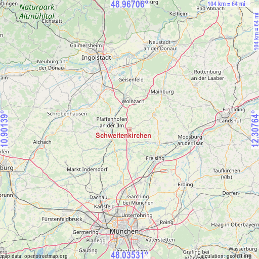
Schweitenkirchen GPS coordinates[2]
48° 30' 11.988" North, 11° 36' 16.236" East
| Map corner | latitude | longitude |
|---|---|---|
| Upper-left | 48.96706°, | 10.90139° |
| Center: | 48.50333°, | 11.60451° |
| Lower-right: | 48.03531°, | 12.30764° |
| Map W x H: | 103.6×103.6 km | = 64.4×64.4mi |
| max Lat: | 55.01917° ⇑89.1% North |
| Schweitenkirchen: | 48.50333° |
| min Lat: | ⇓10.9% South 47.40724° |
| min Long | Schweitenkirche | max Long |
| 5.92978° | 11.60451° | 14.98853° |
| W 75.8%⇐ | ⇒24.2% E |
Elevation
Elevation of Schweitenkirchen is 505 m = 1657 ft, and this is 255.9 m = 840 ft above average elevation for this country.
| Max E: |
1256 m = 4121 ft | 10.8% |
| Schweitenkirchen | 505 m 1657 ft | |
| Avg. | 249.1 m = 817 ft | |
Min E: |
-5 m = -16 ft | 89.2% |
See also: Germany elevation on elevation.city.
Geographical zone
Schweitenkirchen is located in North temperate zone (between Tropic of Cancer and the Arctic Circle). Distance of this North polar circle is 2008.1 km =1247.8 mi to North.| Distance of | km | miles | from Schweitenkirchen |
|---|---|---|---|
| North Pole | 4614 | 2867 | to North |
| Arctic Circle | 2008.1 | 1247.8 | to North |
| Tropic Cancer | 2787.1 | 1731.8 | to South |
| Equator | 5393.1 | 3351.1 | to South |


Nearby cities:
15 places around Schweitenkirchen: (largest is in red/bold)
• Allershausen
7.8 km =4.8 mi,  182°
182°
• Attenkirchen
11.5 km =7.1 mi,  88°
88°
• Au in der Hallertau
11.8 km =7.3 mi,  58°
58°
• Hettenshausen
7.7 km =4.8 mi,  267°
267°
• Hohenkammer
10.6 km =6.6 mi,  213°
213°
• Ilmmünster
8 km =5 mi,  253°
253°
• Kirchdorf
6.1 km =3.8 mi,  143°
143°
• Kranzberg
10.8 km =6.7 mi, 176°
• Paunzhausen
4.3 km =2.7 mi,  222°
222°
• Pfaffenhofen an der Ilm
7.9 km =4.9 mi,  292°
292°
• Reichertshausen
7.7 km =4.8 mi,  237°
237°
• Rohrbach
12.9 km =8 mi,  347°
347°
• Scheyern
10.2 km =6.3 mi, 267°
• Wolfersdorf
8.2 km =5.1 mi,  109°
109°
• Wolnzach
11.3 km =7 mi,  7°
7°
Sources, notices
• [Note1] Compared only with cities in Germany existing in our database
• [Src1] Map data: © OpenStreetMap contributors (CC-BY-SA)
• [Src2] Other city data from geonames.org with taken over terms of usage.
• [Src3] Geographical zone / Annual Mean Temperature by Robert A. Rohde @ Wikipedia
