Wolnzach geodata
Wolnzach (Bavaria) is a populated place; located in Germany in Europe/Berlin (GMT+2) time zone. With population of 10,973 people, there are 1510 cities with bigger population in this country. Compared to other cities in Germany, 87.8% of cities are located further ↑North; 76.1% of cities are located further ←West and 77.2% of cities have lower elevation than Wolnzach. Note1
Administrative division(s):
- Level 1: Bavaria
- Level 2: Upper Bavaria
- Level 3: Landkreis Pfaffenhofen an der Ilm
- Level 4: Wolnzach, Markt


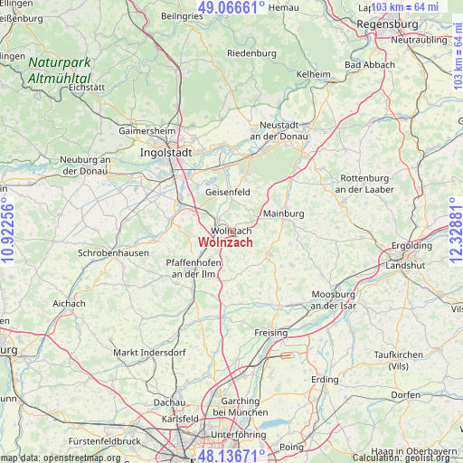
Wolnzach GPS coordinates[2]
48° 36' 13.68" North, 11° 37' 32.448" East
| Map corner | latitude | longitude |
|---|---|---|
| Upper-left | 49.06661°, | 10.92256° |
| Center: | 48.6038°, | 11.62568° |
| Lower-right: | 48.13671°, | 12.32881° |
| Map W x H: | 103.4×103.4 km | = 64.2×64.2mi |
| max Lat: | 55.01917° ⇑87.8% North |
| Wolnzach: | 48.6038° |
| min Lat: | ⇓12.2% South 47.40724° |
| min Long | Wolnzach | max Long |
| 5.92978° | 11.62568° | 14.98853° |
| W 76.1%⇐ | ⇒23.9% E |
Elevation
Elevation of Wolnzach is 413 m = 1355 ft, and this is 163.9 m = 538 ft above average elevation for this country.
| Max E: |
1256 m = 4121 ft | 22.8% |
| Wolnzach | 413 m 1355 ft | |
| Avg. | 249.1 m = 817 ft | |
Min E: |
-5 m = -16 ft | 77.2% |
See also: Germany elevation on elevation.city.
Geographical zone
Wolnzach is located in North temperate zone (between Tropic of Cancer and the Arctic Circle). Distance of this North polar circle is 1996.9 km =1240.8 mi to North.| Distance of | km | miles | from Wolnzach |
|---|---|---|---|
| North Pole | 4602.8 | 2860 | to North |
| Arctic Circle | 1996.9 | 1240.8 | to North |
| Tropic Cancer | 2798.3 | 1738.8 | to South |
| Equator | 5404.2 | 3358 | to South |


Nearby cities:
15 places around Wolnzach: (largest is in red/bold)
• Aiglsbach
11.5 km =7.1 mi,  31°
31°
• Attenkirchen
14.8 km =9.2 mi,  137°
137°
• Au in der Hallertau
9.9 km =6.2 mi,  120°
120°
• Baar-Ebenhausen
13.7 km =8.5 mi,  302°
302°
• Ernsgaden
14.7 km =9.1 mi,  347°
347°
• Geisenfeld
9 km =5.6 mi, 353°
• Hettenshausen
14.8 km =9.2 mi,  218°
218°
• Kirchdorf
10.3 km =6.4 mi,  97°
97°
• Mainburg
12.2 km =7.6 mi,  69°
69°
• Pfaffenhofen an der Ilm
12.1 km =7.5 mi,  227°
227°
• Pörnbach
11.8 km =7.3 mi,  276°
276°
• Reichertshofen
13.2 km =8.2 mi, 297°
• Rohrbach
4.6 km =2.9 mi,  288°
288°
• Rudelzhausen
10.4 km =6.5 mi,  92°
92°
• Schweitenkirchen
11.3 km =7 mi,  187°
187°
Sources, notices
• [Note1] Compared only with cities in Germany existing in our database
• [Src1] Map data: © OpenStreetMap contributors (CC-BY-SA)
• [Src2] Other city data from geonames.org with taken over terms of usage.
• [Src3] Geographical zone / Annual Mean Temperature by Robert A. Rohde @ Wikipedia
