Schwarmstedt geodata
Schwarmstedt (Lower Saxony) is a seat of a fourth-order administrative division; located in Germany in Europe/Berlin (GMT+2) time zone. With population of 5,159 people, there are 2764 cities with bigger population in this country. Compared to other cities in Germany, 79.5% of cities are located further ↓South; 55.8% of cities are located further →East and 87% of cities have higher elevation than Schwarmstedt. Note1
Administrative division(s):
- Level 1: Lower Saxony
- Level 3: Landkreis Heidekreis
- Level 4: Schwarmstedt


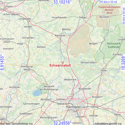
Schwarmstedt GPS coordinates[2]
52° 40' 40.584" North, 9° 37' 3.612" East
| Map corner | latitude | longitude |
|---|---|---|
| Upper-left | 53.10216°, | 8.91455° |
| Center: | 52.67794°, | 9.61767° |
| Lower-right: | 52.24956°, | 10.3208° |
| Map W x H: | 94.8×94.8 km | = 58.9×58.9mi |
| max Lat: | 55.01917° ⇑20.5% North |
| Schwarmstedt: | 52.67794° |
| min Lat: | ⇓79.5% South 47.40724° |
| min Long | Schwarmstedt | max Long |
| 5.92978° | 9.61767° | 14.98853° |
| W 44.2%⇐ | ⇒55.8% E |
Elevation
Elevation of Schwarmstedt is 30 m = 98 ft, and this is 219.1 m = 719 ft below average elevation for this country.
| Max E: |
1256 m = 4121 ft | 87% |
| Avg. | 249.1 m = 817 ft | |
| Schwarmstedt | 30 m = 98 ft | |
Min E: |
-5 m = -16 ft | 13% |
See also: Germany elevation on elevation.city.
Geographical zone
Schwarmstedt is located in North temperate zone (between Tropic of Cancer and the Arctic Circle). Distance of this North polar circle is 1543.9 km =959.3 mi to North.| Distance of | km | miles | from Schwarmstedt |
|---|---|---|---|
| North Pole | 4149.8 | 2578.6 | to North |
| Arctic Circle | 1543.9 | 959.3 | to North |
| Tropic Cancer | 3251.3 | 2020.3 | to South |
| Equator | 5857.2 | 3639.5 | to South |


Nearby cities:
15 places around Schwarmstedt: (largest is in red/bold)
• Ahlden
10.1 km =6.3 mi,  333°
333°
• Böhme
15.5 km =9.6 mi,  319°
319°
• Eickeloh
5.7 km =3.5 mi,  352°
352°
• Elze
13.3 km =8.3 mi,  143°
143°
• Essel
2.2 km =1.4 mi,  47°
47°
• Frankenfeld
16.2 km =10.1 mi,  308°
308°
• Gilten
3.4 km =2.1 mi, 316°
• Grethem
6.3 km =3.9 mi, 330°
• Hademstorf
4.1 km =2.5 mi,  13°
13°
• Hodenhagen
9.8 km =6.1 mi, 351°
• Lindwedel
9.1 km =5.7 mi,  148°
148°
• Negenborn
13.8 km =8.6 mi,  175°
175°
• Steimbke
15.5 km =9.6 mi,  260°
260°
• Stöckse
19.2 km =11.9 mi, 257°
• Wietze
14.9 km =9.3 mi,  102°
102°
Sources, notices
• [Note1] Compared only with cities in Germany existing in our database
• [Src1] Map data: © OpenStreetMap contributors (CC-BY-SA)
• [Src2] Other city data from geonames.org with taken over terms of usage.
• [Src3] Geographical zone / Annual Mean Temperature by Robert A. Rohde @ Wikipedia
