Lindwedel geodata
Lindwedel (Lower Saxony) is a seat of a fourth-order administrative division; located in Germany in Europe/Berlin (GMT+2) time zone. With population of 2,418 people, there are 4538 cities with bigger population in this country. Compared to other cities in Germany, 78.8% of cities are located further ↓South; 54.5% of cities are located further →East and 83.7% of cities have higher elevation than Lindwedel. Note1


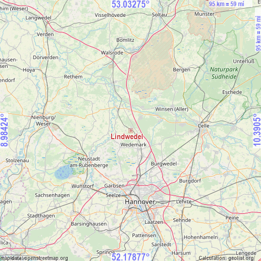
Lindwedel GPS coordinates[2]
52° 36' 28.224" North, 9° 41' 14.532" East
| Map corner | latitude | longitude |
|---|---|---|
| Upper-left | 53.03275°, | 8.98424° |
| Center: | 52.60784°, | 9.68737° |
| Lower-right: | 52.17877°, | 10.3905° |
| Map W x H: | 95×95 km | = 59×59mi |
| max Lat: | 55.01917° ⇑21.2% North |
| Lindwedel: | 52.60784° |
| min Lat: | ⇓78.8% South 47.40724° |
| min Long | Lindwedel | max Long |
| 5.92978° | 9.68737° | 14.98853° |
| W 45.5%⇐ | ⇒54.5% E |
Elevation
Elevation of Lindwedel is 38 m = 125 ft, and this is 211.1 m = 693 ft below average elevation for this country.
| Max E: |
1256 m = 4121 ft | 83.7% |
| Avg. | 249.1 m = 817 ft | |
| Lindwedel | 38 m = 125 ft | |
Min E: |
-5 m = -16 ft | 16.3% |
See also: Germany elevation on elevation.city.
Geographical zone
Lindwedel is located in North temperate zone (between Tropic of Cancer and the Arctic Circle). Distance of this North polar circle is 1551.7 km =964.2 mi to North.| Distance of | km | miles | from Lindwedel |
|---|---|---|---|
| North Pole | 4157.6 | 2583.4 | to North |
| Arctic Circle | 1551.7 | 964.2 | to North |
| Tropic Cancer | 3243.5 | 2015.4 | to South |
| Equator | 5849.4 | 3634.6 | to South |


Nearby cities:
15 places around Lindwedel: (largest is in red/bold)
• Ahlden
19.2 km =11.9 mi,  331°
331°
• Eickeloh
14.5 km =9 mi,  338°
338°
• Elze
4.3 km =2.7 mi,  132°
132°
• Essel
9.8 km =6.1 mi, 341°
• Gilten
12.4 km =7.7 mi, 325°
• Grethem
15.4 km =9.6 mi, 329°
• Hademstorf
12.4 km =7.7 mi, 342°
• Hodenhagen
18.6 km =11.6 mi, 340°
• Isernhagen Farster Bauerschaft
18.5 km =11.5 mi,  145°
145°
• Langenhagen
18.1 km =11.2 mi,  169°
169°
• Negenborn
7.1 km =4.4 mi,  212°
212°
• Schwarmstedt
9.1 km =5.7 mi, 328°
• Wietze
10.9 km =6.8 mi,  64°
64°
• Winsen
17.4 km =10.8 mi, 61°
• Winsen (Aller)
17.2 km =10.7 mi, 60°
Sources, notices
• [Note1] Compared only with cities in Germany existing in our database
• [Src1] Map data: © OpenStreetMap contributors (CC-BY-SA)
• [Src2] Other city data from geonames.org with taken over terms of usage.
• [Src3] Geographical zone / Annual Mean Temperature by Robert A. Rohde @ Wikipedia
