Steimbke geodata
Steimbke (Lower Saxony) is a seat of a fourth-order administrative division; located in Germany in Europe/Berlin (GMT+2) time zone. With population of 2,505 people, there are 4438 cities with bigger population in this country. Compared to other cities in Germany, 79.3% of cities are located further ↓South; 59.4% of cities are located further →East and 83.7% of cities have higher elevation than Steimbke. Note1
Administrative division(s):
- Level 1: Lower Saxony
- Level 3: Landkreis Nienburg/Weser
- Level 4: Steimbke


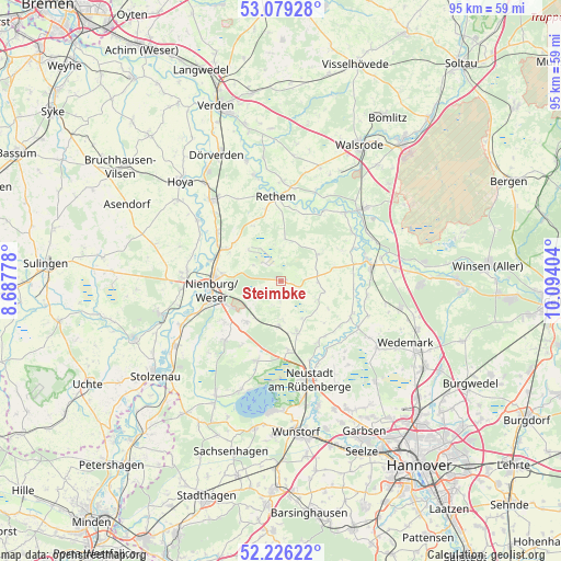
Steimbke GPS coordinates[2]
52° 39' 17.388" North, 9° 23' 27.276" East
| Map corner | latitude | longitude |
|---|---|---|
| Upper-left | 53.07928°, | 8.68778° |
| Center: | 52.65483°, | 9.39091° |
| Lower-right: | 52.22622°, | 10.09404° |
| Map W x H: | 94.9×94.8 km | = 59×58.9mi |
| max Lat: | 55.01917° ⇑20.7% North |
| Steimbke: | 52.65483° |
| min Lat: | ⇓79.3% South 47.40724° |
| min Long | Steimbke | max Long |
| 5.92978° | 9.39091° | 14.98853° |
| W 40.6%⇐ | ⇒59.4% E |
Elevation
Elevation of Steimbke is 38 m = 125 ft, and this is 211.1 m = 693 ft below average elevation for this country.
| Max E: |
1256 m = 4121 ft | 83.7% |
| Avg. | 249.1 m = 817 ft | |
| Steimbke | 38 m = 125 ft | |
Min E: |
-5 m = -16 ft | 16.3% |
See also: Germany elevation on elevation.city.
Geographical zone
Steimbke is located in North temperate zone (between Tropic of Cancer and the Arctic Circle). Distance of this North polar circle is 1546.5 km =961 mi to North.| Distance of | km | miles | from Steimbke |
|---|---|---|---|
| North Pole | 4152.4 | 2580.2 | to North |
| Arctic Circle | 1546.5 | 961 | to North |
| Tropic Cancer | 3248.7 | 2018.6 | to South |
| Equator | 5854.7 | 3637.9 | to South |


Nearby cities:
15 places around Steimbke: (largest is in red/bold)
• Böhme
15.2 km =9.4 mi,  19°
19°
• Drakenburg
12.7 km =7.9 mi,  286°
286°
• Frankenfeld
12.9 km =8 mi,  11°
11°
• Gilten
13.9 km =8.6 mi,  68°
68°
• Grethem
14.6 km =9.1 mi,  56°
56°
• Haßbergen
13.7 km =8.5 mi,  309°
309°
• Heemsen
9.8 km =6.1 mi,  300°
300°
• Husum
13.7 km =8.5 mi,  224°
224°
• Hämelhausen
15.8 km =9.8 mi,  332°
332°
• Linsburg
9.1 km =5.7 mi, 221°
• Nienburg
11.5 km =7.1 mi,  265°
265°
• Rethem
14.6 km =9.1 mi,  356°
356°
• Röhrsen
12.4 km =7.7 mi, 300°
• Schwarmstedt
15.5 km =9.6 mi,  80°
80°
• Stöckse
3.8 km =2.4 mi,  245°
245°
Sources, notices
• [Note1] Compared only with cities in Germany existing in our database
• [Src1] Map data: © OpenStreetMap contributors (CC-BY-SA)
• [Src2] Other city data from geonames.org with taken over terms of usage.
• [Src3] Geographical zone / Annual Mean Temperature by Robert A. Rohde @ Wikipedia
