Ettenheim geodata
Ettenheim (Baden-Württemberg) is a populated place; located in Germany in Europe/Berlin (GMT+2) time zone. With population of 11,995 people, there are 1370 cities with bigger population in this country. Compared to other cities in Germany, 91.8% of cities are located further ↑North; 80.8% of cities are located further →East and 57.2% of cities have higher elevation than Ettenheim. Note1
Administrative division(s):
- Level 1: Baden-Württemberg
- Level 2: Freiburg Region
- Level 3: Ortenaukreis
- Level 4: Ettenheim


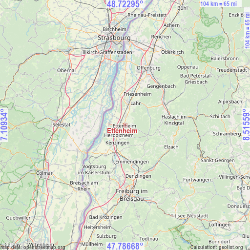
Ettenheim GPS coordinates[2]
48° 15' 25.056" North, 7° 48' 44.892" East
| Map corner | latitude | longitude |
|---|---|---|
| Upper-left | 48.72295°, | 7.10934° |
| Center: | 48.25696°, | 7.81247° |
| Lower-right: | 47.78668°, | 8.51559° |
| Map W x H: | 104.1×104.1 km | = 64.7×64.7mi |
| max Lat: | 55.01917° ⇑91.8% North |
| Ettenheim: | 48.25696° |
| min Lat: | ⇓8.2% South 47.40724° |
| min Long | Ettenheim | max Long |
| 5.92978° | 7.81247° | 14.98853° |
| W 19.2%⇐ | ⇒80.8% E |
Elevation
Elevation of Ettenheim is 173 m = 568 ft, and this is 76.1 m = 250 ft below average elevation for this country.
| Max E: |
1256 m = 4121 ft | 57.2% |
| Avg. | 249.1 m = 817 ft | |
| Ettenheim | 173 m = 568 ft | |
Min E: |
-5 m = -16 ft | 42.8% |
See also: Germany elevation on elevation.city.
Geographical zone
Ettenheim is located in North temperate zone (between Tropic of Cancer and the Arctic Circle). Distance of this North polar circle is 2035.5 km =1264.8 mi to North.| Distance of | km | miles | from Ettenheim |
|---|---|---|---|
| North Pole | 4641.4 | 2884 | to North |
| Arctic Circle | 2035.5 | 1264.8 | to North |
| Tropic Cancer | 2759.8 | 1714.9 | to South |
| Equator | 5365.7 | 3334.1 | to South |


Nearby cities:
15 places around Ettenheim: (largest is in red/bold)
• Grafenhausen
4.5 km =2.8 mi,  311°
311°
• Herbolzheim
5 km =3.1 mi,  211°
211°
• Hohberg
9.8 km =6.1 mi,  41°
41°
• Kappel-Grafenhausen
4.6 km =2.9 mi, 311°
• Kenzingen
7.5 km =4.7 mi, 205°
• Kippenheim
4.4 km =2.7 mi,  12°
12°
• Lahr
10.2 km =6.3 mi,  24°
24°
• Mahlberg
3.3 km =2.1 mi,  2°
2°
• Malterdingen
11.3 km =7 mi,  189°
189°
• Riegel
12.7 km =7.9 mi,  201°
201°
• Ringsheim
2.7 km =1.7 mi,  247°
247°
• Rust
6 km =3.7 mi,  280°
280°
• Schuttertal
10.2 km =6.3 mi,  83°
83°
• Seelbach
11.2 km =7 mi,  57°
57°
• Weisweil
11.9 km =7.4 mi,  237°
237°
Sources, notices
• [Note1] Compared only with cities in Germany existing in our database
• [Src1] Map data: © OpenStreetMap contributors (CC-BY-SA)
• [Src2] Other city data from geonames.org with taken over terms of usage.
• [Src3] Geographical zone / Annual Mean Temperature by Robert A. Rohde @ Wikipedia
