Königswinter geodata
Königswinter (North Rhine-Westphalia) is a populated place; located in Germany in Europe/Berlin (GMT+2) time zone. With population of 41,164 people, there are 308 cities with bigger population in this country. Compared to other cities in Germany, 51.7% of cities are located further ↓South; 91.5% of cities are located further →East and 75.8% of cities have higher elevation than Königswinter. Note1
Administrative division(s):
- Level 1: North Rhine-Westphalia
- Level 2: Regierungsbezirk Köln
- Level 3: Rhein-Sieg-Kreis
- Level 4: Königswinter


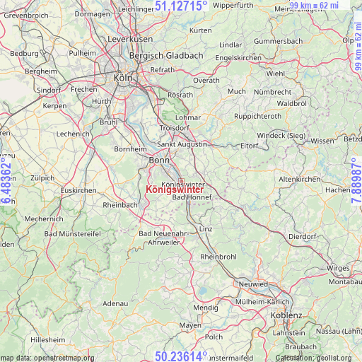
Königswinter GPS coordinates[2]
50° 41' 1.536" North, 7° 11' 12.3" East
| Map corner | latitude | longitude |
|---|---|---|
| Upper-left | 51.12715°, | 6.48362° |
| Center: | 50.68376°, | 7.18675° |
| Lower-right: | 50.23614°, | 7.88987° |
| Map W x H: | 99.1×99.1 km | = 61.6×61.6mi |
| max Lat: | 55.01917° ⇑48.3% North |
| Königswinter: | 50.68376° |
| min Lat: | ⇓51.7% South 47.40724° |
| min Long | Königswinter | max Long |
| 5.92978° | 7.18675° | 14.98853° |
| W 8.5%⇐ | ⇒91.5% E |
Elevation
Elevation of Königswinter is 60 m = 197 ft, and this is 189.1 m = 620 ft below average elevation for this country.
| Max E: |
1256 m = 4121 ft | 75.8% |
| Avg. | 249.1 m = 817 ft | |
| Königswinter | 60 m = 197 ft | |
Min E: |
-5 m = -16 ft | 24.2% |
See also: Königswinter elevation on elevation.city.
Geographical zone
Königswinter is located in North temperate zone (between Tropic of Cancer and the Arctic Circle). Distance of this North polar circle is 1765.7 km =1097.2 mi to North.| Distance of | km | miles | from Königswinter |
|---|---|---|---|
| North Pole | 4371.6 | 2716.4 | to North |
| Arctic Circle | 1765.7 | 1097.2 | to North |
| Tropic Cancer | 3029.6 | 1882.5 | to South |
| Equator | 5635.5 | 3501.7 | to South |


Nearby cities:
15 places around Königswinter: (largest is in red/bold)
• Bad Honnef
5.3 km =3.3 mi,  147°
147°
• Bonn
8.5 km =5.3 mi,  311°
311°
• Boseroth
6.6 km =4.1 mi,  72°
72°
• Bruchhausen
10.3 km =6.4 mi, 154°
• Erpel
11.6 km =7.2 mi,  163°
163°
• Hennef
12.3 km =7.6 mi,  33°
33°
• Kalenborn
11.8 km =7.3 mi,  130°
130°
• Kasbach-Ohlenberg
12.5 km =7.8 mi, 153°
• Remagen
12 km =7.5 mi,  166°
166°
• Rheinbreitbach
8.2 km =5.1 mi, 156°
• Sankt Augustin
10.2 km =6.3 mi,  4°
4°
• Stoßdorf
11.9 km =7.4 mi,  22°
22°
• Unkel
10 km =6.2 mi, 166°
• Wachtberg
8.3 km =5.2 mi,  227°
227°
• Windhagen
12.7 km =7.9 mi,  111°
111°
Sources, notices
• [Note1] Compared only with cities in Germany existing in our database
• [Src1] Map data: © OpenStreetMap contributors (CC-BY-SA)
• [Src2] Other city data from geonames.org with taken over terms of usage.
• [Src3] Geographical zone / Annual Mean Temperature by Robert A. Rohde @ Wikipedia
