Sangerhausen geodata
Sangerhausen (Saxony-Anhalt) is a seat of a third-order administrative division; located in Germany in Europe/Berlin (GMT+2) time zone. With population of 23,347 people, there are 638 cities with bigger population in this country. Compared to other cities in Germany, 65.9% of cities are located further ↓South; 71.2% of cities are located further ←West and 59.8% of cities have higher elevation than Sangerhausen. Note1


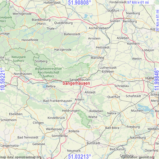
Sangerhausen GPS coordinates[2]
51° 28' 19.956" North, 11° 17' 43.188" East
| Map corner | latitude | longitude |
|---|---|---|
| Upper-left | 51.90808°, | 10.59221° |
| Center: | 51.47221°, | 11.29533° |
| Lower-right: | 51.03213°, | 11.99846° |
| Map W x H: | 97.4×97.4 km | = 60.5×60.5mi |
| max Lat: | 55.01917° ⇑34.1% North |
| Sangerhausen: | 51.47221° |
| min Lat: | ⇓65.9% South 47.40724° |
| min Long | Sangerhausen | max Long |
| 5.92978° | 11.29533° | 14.98853° |
| W 71.2%⇐ | ⇒28.8% E |
Elevation
Elevation of Sangerhausen is 154 m = 505 ft, and this is 95.1 m = 312 ft below average elevation for this country.
| Max E: |
1256 m = 4121 ft | 59.8% |
| Avg. | 249.1 m = 817 ft | |
| Sangerhausen | 154 m = 505 ft | |
Min E: |
-5 m = -16 ft | 40.2% |
See also: Germany elevation on elevation.city.
Geographical zone
Sangerhausen is located in North temperate zone (between Tropic of Cancer and the Arctic Circle). Distance of this North polar circle is 1678 km =1042.7 mi to North.| Distance of | km | miles | from Sangerhausen |
|---|---|---|---|
| North Pole | 4283.9 | 2661.9 | to North |
| Arctic Circle | 1678 | 1042.7 | to North |
| Tropic Cancer | 3117.3 | 1937 | to South |
| Equator | 5723.2 | 3556.2 | to South |


Nearby cities:
15 places around Sangerhausen: (largest is in red/bold)
• Allstedt
9.9 km =6.2 mi,  140°
140°
• Beyernaumburg
6.9 km =4.3 mi,  88°
88°
• Blankenheim
10 km =6.2 mi,  67°
67°
• Borxleben
9.1 km =5.7 mi,  208°
208°
• Brücken
7.4 km =4.6 mi,  244°
244°
• Edersleben
6.2 km =3.9 mi,  187°
187°
• Emseloh
7.4 km =4.6 mi,  63°
63°
• Gonna
4.6 km =2.9 mi,  25°
25°
• Oberröblingen
4 km =2.5 mi,  167°
167°
• Obersdorf
5.8 km =3.6 mi,  21°
21°
• Riestedt
5.2 km =3.2 mi, 60°
• Riethnordhausen
7 km =4.3 mi,  215°
215°
• Voigtstedt
9 km =5.6 mi, 174°
• Wallhausen
6.2 km =3.9 mi,  258°
258°
• Wettelrode
4.9 km =3 mi,  353°
353°
Sources, notices
• [Note1] Compared only with cities in Germany existing in our database
• [Src1] Map data: © OpenStreetMap contributors (CC-BY-SA)
• [Src2] Other city data from geonames.org with taken over terms of usage.
• [Src3] Geographical zone / Annual Mean Temperature by Robert A. Rohde @ Wikipedia
