Beyernaumburg geodata
Beyernaumburg (Saxony-Anhalt) is a populated place; located in Germany in Europe/Berlin (GMT+2) time zone. With population of 772 people, there are 8010 cities with bigger population in this country. Compared to other cities in Germany, 65.9% of cities are located further ↓South; 72.6% of cities are located further ←West and 53.4% of cities have lower elevation than Beyernaumburg. Note1


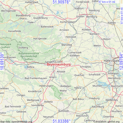
Beyernaumburg GPS coordinates[2]
51° 28' 26.112" North, 11° 23' 40.236" East
| Map corner | latitude | longitude |
|---|---|---|
| Upper-left | 51.90978°, | 10.69139° |
| Center: | 51.47392°, | 11.39451° |
| Lower-right: | 51.03386°, | 12.09764° |
| Map W x H: | 97.4×97.4 km | = 60.5×60.5mi |
| max Lat: | 55.01917° ⇑34.1% North |
| Beyernaumburg: | 51.47392° |
| min Lat: | ⇓65.9% South 47.40724° |
| min Long | Beyernaumburg | max Long |
| 5.92978° | 11.39451° | 14.98853° |
| W 72.6%⇐ | ⇒27.4% E |
Elevation
Elevation of Beyernaumburg is 249 m = 817 ft, and this is 0.099999999999994 m = 0 ft below average elevation for this country.
| Max E: |
1256 m = 4121 ft | 46.6% |
| Avg. | 249.1 m = 817 ft | |
| Beyernaumburg | 249 m = 817 ft | |
Min E: |
-5 m = -16 ft | 53.4% |
See also: Germany elevation on elevation.city.
Geographical zone
Beyernaumburg is located in North temperate zone (between Tropic of Cancer and the Arctic Circle). Distance of this North polar circle is 1677.8 km =1042.5 mi to North.| Distance of | km | miles | from Beyernaumburg |
|---|---|---|---|
| North Pole | 4283.7 | 2661.8 | to North |
| Arctic Circle | 1677.8 | 1042.5 | to North |
| Tropic Cancer | 3117.4 | 1937.1 | to South |
| Equator | 5723.4 | 3556.4 | to South |


Nearby cities:
15 places around Beyernaumburg: (largest is in red/bold)
• Allstedt
7.8 km =4.8 mi,  183°
183°
• Annarode
8.5 km =5.3 mi,  3°
3°
• Blankenheim
4.4 km =2.7 mi,  32°
32°
• Bornstedt
6.2 km =3.9 mi,  80°
80°
• Emseloh
3.1 km =1.9 mi,  356°
356°
• Gonna
6.3 km =3.9 mi,  308°
308°
• Holdenstedt
3.6 km =2.2 mi,  86°
86°
• Mittelhausen
6.4 km =4 mi,  133°
133°
• Oberröblingen
7.3 km =4.5 mi,  235°
235°
• Obersdorf
7.1 km =4.4 mi,  317°
317°
• Osterhausen
7.9 km =4.9 mi,  106°
106°
• Riestedt
3.3 km =2.1 mi, 314°
• Sangerhausen
6.9 km =4.3 mi,  268°
268°
• Wettelrode
8.8 km =5.5 mi,  302°
302°
• Wolferstedt
6.1 km =3.8 mi,  152°
152°
Sources, notices
• [Note1] Compared only with cities in Germany existing in our database
• [Src1] Map data: © OpenStreetMap contributors (CC-BY-SA)
• [Src2] Other city data from geonames.org with taken over terms of usage.
• [Src3] Geographical zone / Annual Mean Temperature by Robert A. Rohde @ Wikipedia
