Emseloh geodata
Emseloh (Saxony-Anhalt) is a populated place; located in Germany in Europe/Berlin (GMT+2) time zone. With population of 610 people, there are 8765 cities with bigger population in this country. Compared to other cities in Germany, 66.4% of cities are located further ↓South; 72.6% of cities are located further ←West and 50.7% of cities have higher elevation than Emseloh. Note1


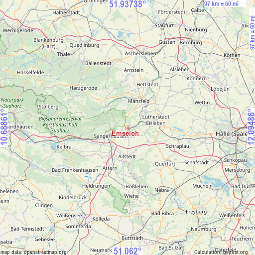
Emseloh GPS coordinates[2]
51° 30' 6.444" North, 11° 23' 30.228" East
| Map corner | latitude | longitude |
|---|---|---|
| Upper-left | 51.93738°, | 10.68861° |
| Center: | 51.50179°, | 11.39173° |
| Lower-right: | 51.062°, | 12.09486° |
| Map W x H: | 97.3×97.3 km | = 60.5×60.5mi |
| max Lat: | 55.01917° ⇑33.6% North |
| Emseloh: | 51.50179° |
| min Lat: | ⇓66.4% South 47.40724° |
| min Long | Emseloh | max Long |
| 5.92978° | 11.39173° | 14.98853° |
| W 72.6%⇐ | ⇒27.4% E |
Elevation
Elevation of Emseloh is 220 m = 722 ft, and this is 29.1 m = 95 ft below average elevation for this country.
| Max E: |
1256 m = 4121 ft | 50.7% |
| Avg. | 249.1 m = 817 ft | |
| Emseloh | 220 m = 722 ft | |
Min E: |
-5 m = -16 ft | 49.3% |
See also: Germany elevation on elevation.city.
Geographical zone
Emseloh is located in North temperate zone (between Tropic of Cancer and the Arctic Circle). Distance of this North polar circle is 1674.7 km =1040.6 mi to North.| Distance of | km | miles | from Emseloh |
|---|---|---|---|
| North Pole | 4280.6 | 2659.8 | to North |
| Arctic Circle | 1674.7 | 1040.6 | to North |
| Tropic Cancer | 3120.5 | 1939 | to South |
| Equator | 5726.5 | 3558.3 | to South |


Nearby cities:
15 places around Emseloh: (largest is in red/bold)
• Ahlsdorf
7.1 km =4.4 mi,  46°
46°
• Annarode
5.4 km =3.4 mi,  8°
8°
• Beyernaumburg
3.1 km =1.9 mi,  176°
176°
• Blankenheim
2.6 km =1.6 mi,  76°
76°
• Bornstedt
6.7 km =4.2 mi,  107°
107°
• Gonna
4.8 km =3 mi,  280°
280°
• Hergisdorf
7.2 km =4.5 mi,  61°
61°
• Holdenstedt
4.8 km =3 mi,  127°
127°
• Obersdorf
5 km =3.1 mi,  294°
294°
• Riestedt
2.3 km =1.4 mi,  250°
250°
• Sangerhausen
7.4 km =4.6 mi,  243°
243°
• Siebigerode
7.4 km =4.6 mi,  19°
19°
• Wettelrode
7.4 km =4.6 mi, 282°
• Wimmelburg
8.2 km =5.1 mi, 75°
• Wolferode
8.4 km =5.2 mi,  86°
86°
Sources, notices
• [Note1] Compared only with cities in Germany existing in our database
• [Src1] Map data: © OpenStreetMap contributors (CC-BY-SA)
• [Src2] Other city data from geonames.org with taken over terms of usage.
• [Src3] Geographical zone / Annual Mean Temperature by Robert A. Rohde @ Wikipedia
