Riestedt geodata
Riestedt (Saxony-Anhalt) is a populated place; located in Germany in Europe/Berlin (GMT+2) time zone. With population of 1,526 people, there are 5830 cities with bigger population in this country. Compared to other cities in Germany, 66.2% of cities are located further ↓South; 72.1% of cities are located further ←West and 56.7% of cities have higher elevation than Riestedt. Note1


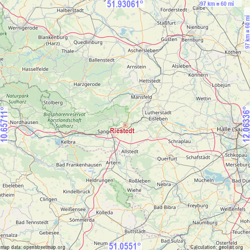
Riestedt GPS coordinates[2]
51° 29' 41.856" North, 11° 21' 36.828" East
| Map corner | latitude | longitude |
|---|---|---|
| Upper-left | 51.93061°, | 10.65711° |
| Center: | 51.49496°, | 11.36023° |
| Lower-right: | 51.0551°, | 12.06336° |
| Map W x H: | 97.3×97.3 km | = 60.5×60.5mi |
| max Lat: | 55.01917° ⇑33.8% North |
| Riestedt: | 51.49496° |
| min Lat: | ⇓66.2% South 47.40724° |
| min Long | Riestedt | max Long |
| 5.92978° | 11.36023° | 14.98853° |
| W 72.1%⇐ | ⇒27.9% E |
Elevation
Elevation of Riestedt is 177 m = 581 ft, and this is 72.1 m = 237 ft below average elevation for this country.
| Max E: |
1256 m = 4121 ft | 56.7% |
| Avg. | 249.1 m = 817 ft | |
| Riestedt | 177 m = 581 ft | |
Min E: |
-5 m = -16 ft | 43.3% |
See also: Germany elevation on elevation.city.
Geographical zone
Riestedt is located in North temperate zone (between Tropic of Cancer and the Arctic Circle). Distance of this North polar circle is 1675.5 km =1041.1 mi to North.| Distance of | km | miles | from Riestedt |
|---|---|---|---|
| North Pole | 4281.4 | 2660.3 | to North |
| Arctic Circle | 1675.5 | 1041.1 | to North |
| Tropic Cancer | 3119.8 | 1938.6 | to South |
| Equator | 5725.7 | 3557.8 | to South |


Nearby cities:
15 places around Riestedt: (largest is in red/bold)
• Ahlsdorf
9.3 km =5.8 mi,  52°
52°
• Annarode
6.8 km =4.2 mi,  25°
25°
• Beyernaumburg
3.3 km =2.1 mi,  134°
134°
• Blankenheim
4.9 km =3 mi,  74°
74°
• Bornstedt
8.6 km =5.3 mi,  98°
98°
• Emseloh
2.3 km =1.4 mi, 70°
• Gonna
3 km =1.9 mi,  302°
302°
• Hergisdorf
9.5 km =5.9 mi,  63°
63°
• Holdenstedt
6.3 km =3.9 mi,  109°
109°
• Oberröblingen
7.4 km =4.6 mi,  209°
209°
• Obersdorf
3.8 km =2.4 mi,  320°
320°
• Sangerhausen
5.2 km =3.2 mi,  240°
240°
• Siebigerode
9.1 km =5.7 mi, 31°
• Wettelrode
5.6 km =3.5 mi,  294°
294°
• Wolferstedt
9.3 km =5.8 mi,  146°
146°
Sources, notices
• [Note1] Compared only with cities in Germany existing in our database
• [Src1] Map data: © OpenStreetMap contributors (CC-BY-SA)
• [Src2] Other city data from geonames.org with taken over terms of usage.
• [Src3] Geographical zone / Annual Mean Temperature by Robert A. Rohde @ Wikipedia
