Höhnstedt geodata
Höhnstedt (Saxony-Anhalt) is a populated place; located in Germany in Europe/Berlin (GMT+2) time zone. With population of 1,645 people, there are 5612 cities with bigger population in this country. Compared to other cities in Germany, 66.4% of cities are located further ↓South; 77.8% of cities are located further ←West and 59.1% of cities have higher elevation than Höhnstedt. Note1


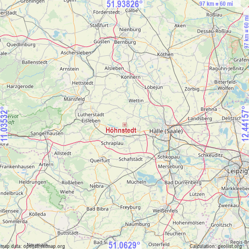
Höhnstedt GPS coordinates[2]
51° 30' 9.648" North, 11° 44' 18.384" East
| Map corner | latitude | longitude |
|---|---|---|
| Upper-left | 51.93826°, | 11.03532° |
| Center: | 51.50268°, | 11.73844° |
| Lower-right: | 51.0629°, | 12.44157° |
| Map W x H: | 97.3×97.3 km | = 60.5×60.5mi |
| max Lat: | 55.01917° ⇑33.6% North |
| Höhnstedt: | 51.50268° |
| min Lat: | ⇓66.4% South 47.40724° |
| min Long | Höhnstedt | max Long |
| 5.92978° | 11.73844° | 14.98853° |
| W 77.8%⇐ | ⇒22.2% E |
Elevation
Elevation of Höhnstedt is 160 m = 525 ft, and this is 89.1 m = 292 ft below average elevation for this country.
| Max E: |
1256 m = 4121 ft | 59.1% |
| Avg. | 249.1 m = 817 ft | |
| Höhnstedt | 160 m = 525 ft | |
Min E: |
-5 m = -16 ft | 40.9% |
See also: Germany elevation on elevation.city.
Geographical zone
Höhnstedt is located in North temperate zone (between Tropic of Cancer and the Arctic Circle). Distance of this North polar circle is 1674.6 km =1040.5 mi to North.| Distance of | km | miles | from Höhnstedt |
|---|---|---|---|
| North Pole | 4280.5 | 2659.8 | to North |
| Arctic Circle | 1674.6 | 1040.5 | to North |
| Tropic Cancer | 3120.6 | 1939.1 | to South |
| Equator | 5726.6 | 3558.3 | to South |


Nearby cities:
15 places around Höhnstedt: (largest is in red/bold)
• Amsdorf
4.3 km =2.7 mi,  190°
190°
• Beesenstedt
7.3 km =4.5 mi,  357°
357°
• Bennstedt
6.5 km =4 mi,  110°
110°
• Erdeborn
7.8 km =4.8 mi,  247°
247°
• Hedersleben
8 km =5 mi,  309°
309°
• Langenbogen
3.5 km =2.2 mi,  128°
128°
• Lüttchendorf
7.7 km =4.8 mi,  269°
269°
• Röblingen am See
6.2 km =3.9 mi,  218°
218°
• Salzmünde
6.6 km =4.1 mi,  66°
66°
• Schochwitz
3.4 km =2.1 mi,  19°
19°
• Seeburg
2.8 km =1.7 mi,  241°
241°
• Stedten
7.3 km =4.5 mi,  205°
205°
• Teutschenthal
7.2 km =4.5 mi,  143°
143°
• Wansleben
4.8 km =3 mi,  169°
169°
• Zappendorf
4 km =2.5 mi,  77°
77°
Sources, notices
• [Note1] Compared only with cities in Germany existing in our database
• [Src1] Map data: © OpenStreetMap contributors (CC-BY-SA)
• [Src2] Other city data from geonames.org with taken over terms of usage.
• [Src3] Geographical zone / Annual Mean Temperature by Robert A. Rohde @ Wikipedia
