Losheim geodata
Losheim (Saarland) is a populated place; located in Germany in Europe/Berlin (GMT+2) time zone. With population of 16,660 people, there are 948 cities with bigger population in this country. Compared to other cities in Germany, 75.5% of cities are located further ↑North; 96.1% of cities are located further →East and 61.1% of cities have lower elevation than Losheim. Note1
Administrative division(s):
- Level 1: Saarland
- Level 3: Landkreis Merzig-Wadern
- Level 4: Losheim am See


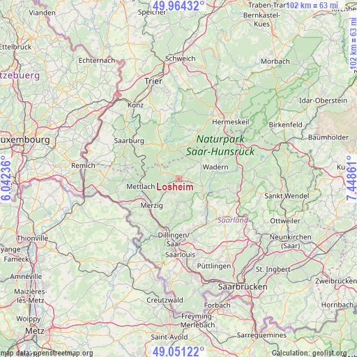
Losheim GPS coordinates[2]
49° 30' 35.64" North, 6° 44' 43.764" East
| Map corner | latitude | longitude |
|---|---|---|
| Upper-left | 49.96432°, | 6.04236° |
| Center: | 49.5099°, | 6.74549° |
| Lower-right: | 49.05122°, | 7.44861° |
| Map W x H: | 101.5×101.5 km | = 63.1×63.1mi |
| max Lat: | 55.01917° ⇑75.5% North |
| Losheim: | 49.5099° |
| min Lat: | ⇓24.5% South 47.40724° |
| min Long | Losheim | max Long |
| 5.92978° | 6.74549° | 14.98853° |
| W 3.9%⇐ | ⇒96.1% E |
Elevation
Elevation of Losheim is 296 m = 971 ft, and this is 46.9 m = 154 ft above average elevation for this country.
| Max E: |
1256 m = 4121 ft | 38.9% |
| Losheim | 296 m 971 ft | |
| Avg. | 249.1 m = 817 ft | |
Min E: |
-5 m = -16 ft | 61.1% |
See also: Germany elevation on elevation.city.
Geographical zone
Losheim is located in North temperate zone (between Tropic of Cancer and the Arctic Circle). Distance of this North polar circle is 1896.2 km =1178.2 mi to North.| Distance of | km | miles | from Losheim |
|---|---|---|---|
| North Pole | 4502.1 | 2797.5 | to North |
| Arctic Circle | 1896.2 | 1178.2 | to North |
| Tropic Cancer | 2899.1 | 1801.4 | to South |
| Equator | 5505 | 3420.6 | to South |


Nearby cities:
15 places around Losheim: (largest is in red/bold)
• Baldringen
12.7 km =7.9 mi,  339°
339°
• Beckingen
12.7 km =7.9 mi,  195°
195°
• Britten
5.1 km =3.2 mi,  283°
283°
• Greimerath
7.3 km =4.5 mi,  322°
322°
• Hentern
12.3 km =7.6 mi, 344°
• Mandern
10.1 km =6.3 mi,  8°
8°
• Merzig
10.7 km =6.6 mi,  226°
226°
• Mettlach
11.7 km =7.3 mi,  261°
261°
• Saarhölzbach
10 km =6.2 mi,  273°
273°
• Schmelz
11.4 km =7.1 mi,  138°
138°
• Taben-Rodt
12.5 km =7.8 mi,  290°
290°
• Wadern
10.8 km =6.7 mi,  71°
71°
• Waldweiler
12.5 km =7.8 mi,  18°
18°
• Weiskirchen
6.8 km =4.2 mi,  49°
49°
• Zerf
11 km =6.8 mi, 335°
Sources, notices
• [Note1] Compared only with cities in Germany existing in our database
• [Src1] Map data: © OpenStreetMap contributors (CC-BY-SA)
• [Src2] Other city data from geonames.org with taken over terms of usage.
• [Src3] Geographical zone / Annual Mean Temperature by Robert A. Rohde @ Wikipedia
