Saal geodata
Saal (Bavaria) is a populated place; located in Germany in Europe/Berlin (GMT+2) time zone. With population of 5,626 people, there are 2583 cities with bigger population in this country. Compared to other cities in Germany, 84% of cities are located further ↑North; 80.8% of cities are located further ←West and 68.7% of cities have lower elevation than Saal. Note1
Administrative division(s):
- Level 1: Bavaria
- Level 2: Lower Bavaria
- Level 3: Landkreis Kelheim
- Level 4: Saal a.d.Donau


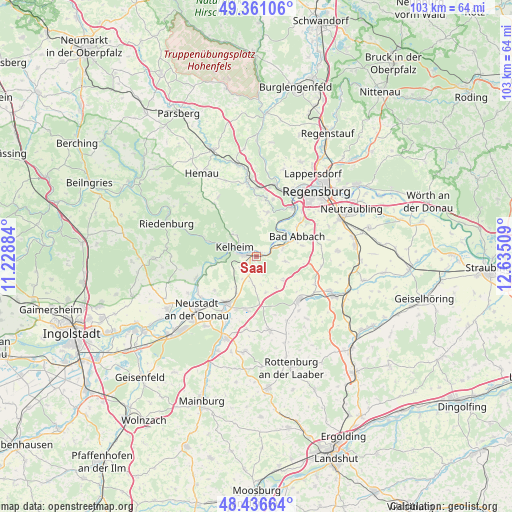
Saal GPS coordinates[2]
48° 54' 3.564" North, 11° 55' 55.056" East
| Map corner | latitude | longitude |
|---|---|---|
| Upper-left | 49.36106°, | 11.22884° |
| Center: | 48.90099°, | 11.93196° |
| Lower-right: | 48.43664°, | 12.63509° |
| Map W x H: | 102.8×102.8 km | = 63.9×63.9mi |
| max Lat: | 55.01917° ⇑84% North |
| Saal: | 48.90099° |
| min Lat: | ⇓16% South 47.40724° |
| min Long | Saal | max Long |
| 5.92978° | 11.93196° | 14.98853° |
| W 80.8%⇐ | ⇒19.2% E |
Elevation
Elevation of Saal is 348 m = 1142 ft, and this is 98.9 m = 324 ft above average elevation for this country.
| Max E: |
1256 m = 4121 ft | 31.3% |
| Saal | 348 m 1142 ft | |
| Avg. | 249.1 m = 817 ft | |
Min E: |
-5 m = -16 ft | 68.7% |
See also: Germany elevation on elevation.city.
Geographical zone
Saal is located in North temperate zone (between Tropic of Cancer and the Arctic Circle). Distance of this North polar circle is 1963.9 km =1220.3 mi to North.| Distance of | km | miles | from Saal |
|---|---|---|---|
| North Pole | 4569.8 | 2839.5 | to North |
| Arctic Circle | 1963.9 | 1220.3 | to North |
| Tropic Cancer | 2831.4 | 1759.3 | to South |
| Equator | 5437.3 | 3378.6 | to South |


Nearby cities:
15 places around Saal: (largest is in red/bold)
• Abensberg
11.1 km =6.9 mi,  212°
212°
• Bad Abbach
9.2 km =5.7 mi,  63°
63°
• Biburg
13.4 km =8.3 mi,  204°
204°
• Essing
11 km =6.8 mi,  289°
289°
• Hausen
7.1 km =4.4 mi,  130°
130°
• Ihrlerstein
6 km =3.7 mi,  307°
307°
• Kelheim
3.8 km =2.4 mi,  298°
298°
• Kirchdorf
14.6 km =9.1 mi,  188°
188°
• Langquaid
12.3 km =7.6 mi, 134°
• Nittendorf
13.9 km =8.6 mi,  8°
8°
• Painten
13.5 km =8.4 mi,  322°
322°
• Pentling
13 km =8.1 mi,  45°
45°
• Rohr
15.1 km =9.4 mi,  168°
168°
• Sinzing
13.3 km =8.3 mi,  33°
33°
• Teugn
5.9 km =3.7 mi,  98°
98°
Sources, notices
• [Note1] Compared only with cities in Germany existing in our database
• [Src1] Map data: © OpenStreetMap contributors (CC-BY-SA)
• [Src2] Other city data from geonames.org with taken over terms of usage.
• [Src3] Geographical zone / Annual Mean Temperature by Robert A. Rohde @ Wikipedia
