Ihrlerstein geodata
Ihrlerstein (Bavaria) is a seat of a fourth-order administrative division; located in Germany in Europe/Berlin (GMT+2) time zone. With population of 4,419 people, there are 3088 cities with bigger population in this country. Compared to other cities in Germany, 83.7% of cities are located further ↑North; 79.7% of cities are located further ←West and 85.1% of cities have lower elevation than Ihrlerstein. Note1
Administrative division(s):
- Level 1: Bavaria
- Level 2: Lower Bavaria
- Level 3: Landkreis Kelheim
- Level 4: Ihrlerstein


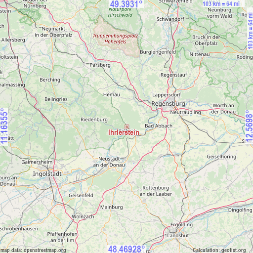
Ihrlerstein GPS coordinates[2]
48° 55' 59.988" North, 11° 52' 0.012" East
| Map corner | latitude | longitude |
|---|---|---|
| Upper-left | 49.3931°, | 11.16355° |
| Center: | 48.93333°, | 11.86667° |
| Lower-right: | 48.46928°, | 12.5698° |
| Map W x H: | 102.7×102.7 km | = 63.8×63.8mi |
| max Lat: | 55.01917° ⇑83.7% North |
| Ihrlerstein: | 48.93333° |
| min Lat: | ⇓16.3% South 47.40724° |
| min Long | Ihrlerstein | max Long |
| 5.92978° | 11.86667° | 14.98853° |
| W 79.7%⇐ | ⇒20.3% E |
Elevation
Elevation of Ihrlerstein is 470 m = 1542 ft, and this is 220.9 m = 725 ft above average elevation for this country.
| Max E: |
1256 m = 4121 ft | 14.9% |
| Ihrlerstein | 470 m 1542 ft | |
| Avg. | 249.1 m = 817 ft | |
Min E: |
-5 m = -16 ft | 85.1% |
See also: Germany elevation on elevation.city.
Geographical zone
Ihrlerstein is located in North temperate zone (between Tropic of Cancer and the Arctic Circle). Distance of this North polar circle is 1960.3 km =1218.1 mi to North.| Distance of | km | miles | from Ihrlerstein |
|---|---|---|---|
| North Pole | 4566.2 | 2837.3 | to North |
| Arctic Circle | 1960.3 | 1218.1 | to North |
| Tropic Cancer | 2835 | 1761.6 | to South |
| Equator | 5440.9 | 3380.8 | to South |


Nearby cities:
15 places around Ihrlerstein: (largest is in red/bold)
• Abensberg
13 km =8.1 mi,  185°
185°
• Bad Abbach
13 km =8.1 mi,  87°
87°
• Deuerling
12 km =7.5 mi,  15°
15°
• Essing
5.6 km =3.5 mi,  271°
271°
• Hausen
13.1 km =8.1 mi,  128°
128°
• Hemau
14.8 km =9.2 mi,  335°
335°
• Kelheim
2.3 km =1.4 mi,  141°
141°
• Neustadt an der Donau
15.7 km =9.8 mi,  206°
206°
• Nittendorf
12.3 km =7.6 mi,  34°
34°
• Painten
7.9 km =4.9 mi,  334°
334°
• Pentling
15.1 km =9.4 mi,  68°
68°
• Riedenburg
13.4 km =8.3 mi,  284°
284°
• Saal
6 km =3.7 mi, 127°
• Sinzing
14.2 km =8.8 mi,  58°
58°
• Teugn
11.5 km =7.1 mi,  112°
112°
Sources, notices
• [Note1] Compared only with cities in Germany existing in our database
• [Src1] Map data: © OpenStreetMap contributors (CC-BY-SA)
• [Src2] Other city data from geonames.org with taken over terms of usage.
• [Src3] Geographical zone / Annual Mean Temperature by Robert A. Rohde @ Wikipedia
