Teugn geodata
Teugn (Bavaria) is a seat of a fourth-order administrative division; located in Germany in Europe/Berlin (GMT+2) time zone. With population of 1,508 people, there are 5867 cities with bigger population in this country. Compared to other cities in Germany, 84.2% of cities are located further ↑North; 81.9% of cities are located further ←West and 72.5% of cities have lower elevation than Teugn. Note1
Administrative division(s):
- Level 1: Bavaria
- Level 2: Lower Bavaria
- Level 3: Landkreis Kelheim
- Level 4: Teugn


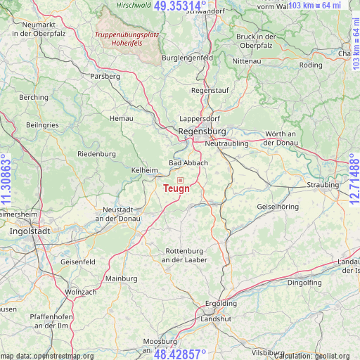
Teugn GPS coordinates[2]
48° 53' 34.764" North, 12° 0' 42.3" East
| Map corner | latitude | longitude |
|---|---|---|
| Upper-left | 49.35314°, | 11.30863° |
| Center: | 48.89299°, | 12.01175° |
| Lower-right: | 48.42857°, | 12.71488° |
| Map W x H: | 102.8×102.8 km | = 63.9×63.9mi |
| max Lat: | 55.01917° ⇑84.2% North |
| Teugn: | 48.89299° |
| min Lat: | ⇓15.8% South 47.40724° |
| min Long | Teugn | max Long |
| 5.92978° | 12.01175° | 14.98853° |
| W 81.9%⇐ | ⇒18.1% E |
Elevation
Elevation of Teugn is 378 m = 1240 ft, and this is 128.9 m = 423 ft above average elevation for this country.
| Max E: |
1256 m = 4121 ft | 27.5% |
| Teugn | 378 m 1240 ft | |
| Avg. | 249.1 m = 817 ft | |
Min E: |
-5 m = -16 ft | 72.5% |
See also: Germany elevation on elevation.city.
Geographical zone
Teugn is located in North temperate zone (between Tropic of Cancer and the Arctic Circle). Distance of this North polar circle is 1964.8 km =1220.9 mi to North.| Distance of | km | miles | from Teugn |
|---|---|---|---|
| North Pole | 4570.7 | 2840.1 | to North |
| Arctic Circle | 1964.8 | 1220.9 | to North |
| Tropic Cancer | 2830.5 | 1758.8 | to South |
| Equator | 5436.4 | 3378 | to South |


Nearby cities:
15 places around Teugn: (largest is in red/bold)
• Alteglofsheim
14 km =8.7 mi,  79°
79°
• Bad Abbach
5.5 km =3.4 mi,  26°
26°
• Hausen
3.7 km =2.3 mi,  186°
186°
• Herrngiersdorf
12.4 km =7.7 mi,  159°
159°
• Ihrlerstein
11.5 km =7.1 mi,  292°
292°
• Kelheim
9.6 km =6 mi, 286°
• Köfering
14.5 km =9 mi,  71°
71°
• Langquaid
8.3 km =5.2 mi, 159°
• Obertraubling
14 km =8.7 mi,  54°
54°
• Pentling
10.6 km =6.6 mi,  18°
18°
• Rohr
14.2 km =8.8 mi, 191°
• Saal
5.9 km =3.7 mi,  278°
278°
• Schierling
11.4 km =7.1 mi,  124°
124°
• Sinzing
12 km =7.5 mi,  7°
7°
• Thalmassing
10.7 km =6.6 mi, 78°
Sources, notices
• [Note1] Compared only with cities in Germany existing in our database
• [Src1] Map data: © OpenStreetMap contributors (CC-BY-SA)
• [Src2] Other city data from geonames.org with taken over terms of usage.
• [Src3] Geographical zone / Annual Mean Temperature by Robert A. Rohde @ Wikipedia
