Großwoltersdorf geodata
Großwoltersdorf (Brandenburg) is a seat of a fourth-order administrative division; located in Germany in Europe/Berlin (GMT+2) time zone. With population of 1,003 people, there are 7169 cities with bigger population in this country. Compared to other cities in Germany, 82.1% of cities are located further ↓South; 93% of cities are located further ←West and 75.5% of cities have higher elevation than Großwoltersdorf. Note1
Administrative division(s):
- Level 1: Brandenburg
- Level 3: Landkreis Oberhavel
- Level 4: Großwoltersdorf


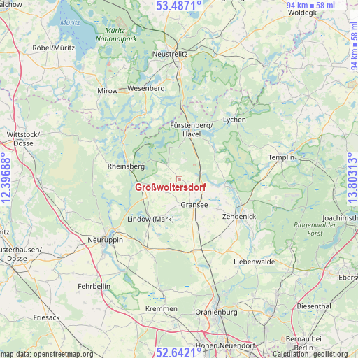
Großwoltersdorf GPS coordinates[2]
53° 4' 0.012" North, 13° 6' 0" East
| Map corner | latitude | longitude |
|---|---|---|
| Upper-left | 53.4871°, | 12.39688° |
| Center: | 53.06667°, | 13.1° |
| Lower-right: | 52.6421°, | 13.80313° |
| Map W x H: | 94×94 km | = 58.4×58.4mi |
| max Lat: | 55.01917° ⇑17.9% North |
| Großwoltersdorf: | 53.06667° |
| min Lat: | ⇓82.1% South 47.40724° |
| min Long | Großwoltersdor | max Long |
| 5.92978° | 13.1° | 14.98853° |
| W 93%⇐ | ⇒7% E |
Elevation
Elevation of Großwoltersdorf is 61 m = 200 ft, and this is 188.1 m = 617 ft below average elevation for this country.
| Max E: |
1256 m = 4121 ft | 75.5% |
| Avg. | 249.1 m = 817 ft | |
| Großwoltersdorf | 61 m = 200 ft | |
Min E: |
-5 m = -16 ft | 24.5% |
See also: Germany elevation on elevation.city.
Geographical zone
Großwoltersdorf is located in North temperate zone (between Tropic of Cancer and the Arctic Circle). Distance of this North polar circle is 1500.7 km =932.5 mi to North.| Distance of | km | miles | from Großwoltersdorf |
|---|---|---|---|
| North Pole | 4106.6 | 2551.7 | to North |
| Arctic Circle | 1500.7 | 932.5 | to North |
| Tropic Cancer | 3294.5 | 2047.1 | to South |
| Equator | 5900.5 | 3666.4 | to South |


Nearby cities:
15 places around Großwoltersdorf: (largest is in red/bold)
• Dabergotz
31 km =19.3 mi,  234°
234°
• Fürstenberg
13.4 km =8.3 mi,  12°
12°
• Gransee
7.7 km =4.8 mi,  149°
149°
• Herzberg
20.2 km =12.6 mi,  205°
205°
• Liebenwalde
29.4 km =18.3 mi,  137°
137°
• Lindow
13.5 km =8.4 mi, 214°
• Lychen
21.6 km =13.4 mi,  41°
41°
• Neuruppin
25.1 km =15.6 mi, 232°
• Rheinsberg
13.9 km =8.6 mi,  285°
285°
• Rüthnick
21.8 km =13.5 mi,  198°
198°
• Schönermark
6.8 km =4.2 mi,  168°
168°
• Sonnenberg
5.3 km =3.3 mi,  188°
188°
• Templin
27.5 km =17.1 mi,  77°
77°
• Wesenberg
25.3 km =15.7 mi,  339°
339°
• Zehdenick
18.3 km =11.4 mi,  122°
122°
Sources, notices
• [Note1] Compared only with cities in Germany existing in our database
• [Src1] Map data: © OpenStreetMap contributors (CC-BY-SA)
• [Src2] Other city data from geonames.org with taken over terms of usage.
• [Src3] Geographical zone / Annual Mean Temperature by Robert A. Rohde @ Wikipedia
