Zehdenick geodata
Zehdenick (Brandenburg) is a populated place; located in Germany in Europe/Berlin (GMT+2) time zone. With population of 14,809 people, there are 1075 cities with bigger population in this country. Compared to other cities in Germany, 81.6% of cities are located further ↓South; 94.5% of cities are located further ←West and 78.3% of cities have higher elevation than Zehdenick. Note1


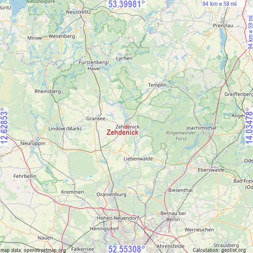
Zehdenick GPS coordinates[2]
52° 58' 42.672" North, 13° 19' 53.94" East
| Map corner | latitude | longitude |
|---|---|---|
| Upper-left | 53.39981°, | 12.62853° |
| Center: | 52.97852°, | 13.33165° |
| Lower-right: | 52.55308°, | 14.03478° |
| Map W x H: | 94.1×94.1 km | = 58.5×58.5mi |
| max Lat: | 55.01917° ⇑18.4% North |
| Zehdenick: | 52.97852° |
| min Lat: | ⇓81.6% South 47.40724° |
| min Long | Zehdenick | max Long |
| 5.92978° | 13.33165° | 14.98853° |
| W 94.5%⇐ | ⇒5.5% E |
Elevation
Elevation of Zehdenick is 52 m = 171 ft, and this is 197.1 m = 647 ft below average elevation for this country.
| Max E: |
1256 m = 4121 ft | 78.3% |
| Avg. | 249.1 m = 817 ft | |
| Zehdenick | 52 m = 171 ft | |
Min E: |
-5 m = -16 ft | 21.7% |
See also: Germany elevation on elevation.city.
Geographical zone
Zehdenick is located in North temperate zone (between Tropic of Cancer and the Arctic Circle). Distance of this North polar circle is 1510.5 km =938.6 mi to North.| Distance of | km | miles | from Zehdenick |
|---|---|---|---|
| North Pole | 4116.4 | 2557.8 | to North |
| Arctic Circle | 1510.5 | 938.6 | to North |
| Tropic Cancer | 3284.7 | 2041 | to South |
| Equator | 5890.7 | 3660.3 | to South |


Nearby cities:
15 places around Zehdenick: (largest is in red/bold)
• Friedrichswalde
25.7 km =16 mi,  77°
77°
• Fürstenberg
26.1 km =16.2 mi,  331°
331°
• Gransee
12.1 km =7.5 mi,  285°
285°
• Großwoltersdorf
18.3 km =11.4 mi,  302°
302°
• Herzberg
25.7 km =16 mi,  250°
250°
• Liebenwalde
12.7 km =7.9 mi,  160°
160°
• Lindow
23.2 km =14.4 mi,  266°
266°
• Lychen
26 km =16.2 mi,  357°
357°
• Marienwerder
23.5 km =14.6 mi,  130°
130°
• Milmersdorf
25.5 km =15.8 mi,  54°
54°
• Oranienburg
25.5 km =15.8 mi,  193°
193°
• Rüthnick
24.9 km =15.5 mi,  244°
244°
• Schönermark
14.5 km =9 mi,  282°
282°
• Sonnenberg
16.9 km =10.5 mi, 285°
• Templin
19.3 km =12 mi,  36°
36°
Sources, notices
• [Note1] Compared only with cities in Germany existing in our database
• [Src1] Map data: © OpenStreetMap contributors (CC-BY-SA)
• [Src2] Other city data from geonames.org with taken over terms of usage.
• [Src3] Geographical zone / Annual Mean Temperature by Robert A. Rohde @ Wikipedia
