Wandlitz geodata
Wandlitz (Brandenburg) is a seat of a fourth-order administrative division; located in Germany in Europe/Berlin (GMT+2) time zone. With population of 19,888 people, there are 783 cities with bigger population in this country. Compared to other cities in Germany, 80% of cities are located further ↓South; 95.5% of cities are located further ←West and 74.3% of cities have higher elevation than Wandlitz. Note1


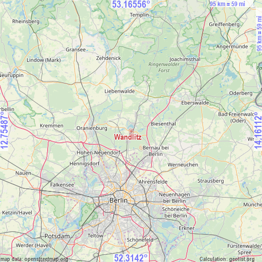
Wandlitz GPS coordinates[2]
52° 44' 31.056" North, 13° 27' 28.764" East
| Map corner | latitude | longitude |
|---|---|---|
| Upper-left | 53.16556°, | 12.75487° |
| Center: | 52.74196°, | 13.45799° |
| Lower-right: | 52.3142°, | 14.16112° |
| Map W x H: | 94.7×94.7 km | = 58.8×58.8mi |
| max Lat: | 55.01917° ⇑20% North |
| Wandlitz: | 52.74196° |
| min Lat: | ⇓80% South 47.40724° |
| min Long | Wandlitz | max Long |
| 5.92978° | 13.45799° | 14.98853° |
| W 95.5%⇐ | ⇒4.5% E |
Elevation
Elevation of Wandlitz is 66 m = 217 ft, and this is 183.1 m = 601 ft below average elevation for this country.
| Max E: |
1256 m = 4121 ft | 74.3% |
| Avg. | 249.1 m = 817 ft | |
| Wandlitz | 66 m = 217 ft | |
Min E: |
-5 m = -16 ft | 25.7% |
See also: Germany elevation on elevation.city.
Geographical zone
Wandlitz is located in North temperate zone (between Tropic of Cancer and the Arctic Circle). Distance of this North polar circle is 1536.8 km =954.9 mi to North.| Distance of | km | miles | from Wandlitz |
|---|---|---|---|
| North Pole | 4142.7 | 2574.2 | to North |
| Arctic Circle | 1536.8 | 954.9 | to North |
| Tropic Cancer | 3258.4 | 2024.7 | to South |
| Equator | 5864.4 | 3644 | to South |


Nearby cities:
15 places around Wandlitz: (largest is in red/bold)
• Bernau bei Berlin
11.1 km =6.9 mi,  128°
128°
• Biesenthal
12.8 km =8 mi,  77°
77°
• Birkenwerder
13.5 km =8.4 mi,  241°
241°
• Blankenfelde
14.4 km =8.9 mi,  198°
198°
• Buch
12.2 km =7.6 mi,  167°
167°
• Französisch Buchholz
15.6 km =9.7 mi,  186°
186°
• Frohnau
16.5 km =10.3 mi,  223°
223°
• Glienicke
15 km =9.3 mi, 216°
• Hohen Neuendorf
14.2 km =8.8 mi, 238°
• Karow
14.9 km =9.3 mi, 173°
• Liebenwalde
15 km =9.3 mi,  343°
343°
• Lübars
15.7 km =9.8 mi,  206°
206°
• Marienwerder
14.6 km =9.1 mi,  40°
40°
• Oranienburg
14.6 km =9.1 mi,  276°
276°
• Rüdnitz
11.5 km =7.1 mi,  101°
101°
Sources, notices
• [Note1] Compared only with cities in Germany existing in our database
• [Src1] Map data: © OpenStreetMap contributors (CC-BY-SA)
• [Src2] Other city data from geonames.org with taken over terms of usage.
• [Src3] Geographical zone / Annual Mean Temperature by Robert A. Rohde @ Wikipedia
