Röttenbach geodata
Röttenbach (Bavaria) is a seat of a fourth-order administrative division; located in Germany in Europe/Berlin (GMT+2) time zone. With population of 2,890 people, there are 4107 cities with bigger population in this country. Compared to other cities in Germany, 81.2% of cities are located further ↑North; 67.4% of cities are located further ←West and 71.8% of cities have lower elevation than Röttenbach. Note1
Administrative division(s):
- Level 1: Bavaria
- Level 2: Regierungsbezirk Mittelfranken
- Level 3: Landkreis Roth
- Level 4: Röttenbach


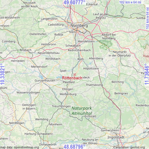
Röttenbach GPS coordinates[2]
49° 9' 0" North, 11° 1' 59.988" East
| Map corner | latitude | longitude |
|---|---|---|
| Upper-left | 49.60777°, | 10.33021° |
| Center: | 49.15°, | 11.03333° |
| Lower-right: | 48.68796°, | 11.73646° |
| Map W x H: | 102.3×102.3 km | = 63.6×63.6mi |
| max Lat: | 55.01917° ⇑81.2% North |
| Röttenbach: | 49.15° |
| min Lat: | ⇓18.8% South 47.40724° |
| min Long | Röttenbach | max Long |
| 5.92978° | 11.03333° | 14.98853° |
| W 67.4%⇐ | ⇒32.6% E |
Elevation
Elevation of Röttenbach is 373 m = 1224 ft, and this is 123.9 m = 406 ft above average elevation for this country.
| Max E: |
1256 m = 4121 ft | 28.2% |
| Röttenbach | 373 m 1224 ft | |
| Avg. | 249.1 m = 817 ft | |
Min E: |
-5 m = -16 ft | 71.8% |
See also: Germany elevation on elevation.city.
Geographical zone
Röttenbach is located in North temperate zone (between Tropic of Cancer and the Arctic Circle). Distance of this North polar circle is 1936.2 km =1203.1 mi to North.| Distance of | km | miles | from Röttenbach |
|---|---|---|---|
| North Pole | 4542.1 | 2822.3 | to North |
| Arctic Circle | 1936.2 | 1203.1 | to North |
| Tropic Cancer | 2859 | 1776.5 | to South |
| Equator | 5465 | 3395.8 | to South |


Nearby cities:
15 places around Röttenbach: (largest is in red/bold)
• Abenberg
11.5 km =7.1 mi,  333°
333°
• Absberg
11.1 km =6.9 mi,  266°
266°
• Bergen
10.3 km =6.4 mi,  145°
145°
• Burgsalach
13.8 km =8.6 mi,  160°
160°
• Büchenbach
13.2 km =8.2 mi,  8°
8°
• Ellingen
11 km =6.8 mi,  205°
205°
• Ettenstatt
8.2 km =5.1 mi,  168°
168°
• Georgensgmünd
4.6 km =2.9 mi,  344°
344°
• Heideck
7.1 km =4.4 mi,  104°
104°
• Hilpoltstein
12.3 km =7.6 mi,  68°
68°
• Höttingen
9.9 km =6.2 mi,  191°
191°
• Nennslingen
13.5 km =8.4 mi, 148°
• Pleinfeld
6.3 km =3.9 mi,  216°
216°
• Roth
11.6 km =7.2 mi,  21°
21°
• Spalt
8.4 km =5.2 mi,  289°
289°
Sources, notices
• [Note1] Compared only with cities in Germany existing in our database
• [Src1] Map data: © OpenStreetMap contributors (CC-BY-SA)
• [Src2] Other city data from geonames.org with taken over terms of usage.
• [Src3] Geographical zone / Annual Mean Temperature by Robert A. Rohde @ Wikipedia
