Heideck geodata
Heideck (Bavaria) is a populated place; located in Germany in Europe/Berlin (GMT+2) time zone. With population of 5,011 people, there are 2827 cities with bigger population in this country. Compared to other cities in Germany, 81.3% of cities are located further ↑North; 68.8% of cities are located further ←West and 76.1% of cities have lower elevation than Heideck. Note1
Administrative division(s):
- Level 1: Bavaria
- Level 2: Regierungsbezirk Mittelfranken
- Level 3: Landkreis Roth
- Level 4: Heideck


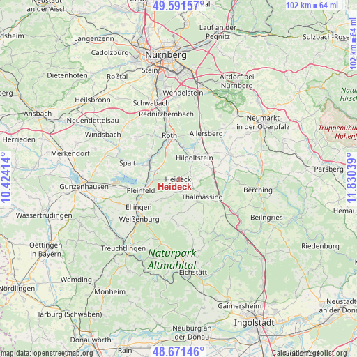
Heideck GPS coordinates[2]
49° 8' 1.14" North, 11° 7' 38.136" East
| Map corner | latitude | longitude |
|---|---|---|
| Upper-left | 49.59157°, | 10.42414° |
| Center: | 49.13365°, | 11.12726° |
| Lower-right: | 48.67146°, | 11.83039° |
| Map W x H: | 102.3×102.3 km | = 63.6×63.6mi |
| max Lat: | 55.01917° ⇑81.3% North |
| Heideck: | 49.13365° |
| min Lat: | ⇓18.7% South 47.40724° |
| min Long | Heideck | max Long |
| 5.92978° | 11.12726° | 14.98853° |
| W 68.8%⇐ | ⇒31.2% E |
Elevation
Elevation of Heideck is 406 m = 1332 ft, and this is 156.9 m = 515 ft above average elevation for this country.
| Max E: |
1256 m = 4121 ft | 23.9% |
| Heideck | 406 m 1332 ft | |
| Avg. | 249.1 m = 817 ft | |
Min E: |
-5 m = -16 ft | 76.1% |
See also: Germany elevation on elevation.city.
Geographical zone
Heideck is located in North temperate zone (between Tropic of Cancer and the Arctic Circle). Distance of this North polar circle is 1938 km =1204.2 mi to North.| Distance of | km | miles | from Heideck |
|---|---|---|---|
| North Pole | 4543.9 | 2823.4 | to North |
| Arctic Circle | 1938 | 1204.2 | to North |
| Tropic Cancer | 2857.2 | 1775.4 | to South |
| Equator | 5463.1 | 3394.6 | to South |


Nearby cities:
15 places around Heideck: (largest is in red/bold)
• Allersberg
15.3 km =9.5 mi,  31°
31°
• Bergen
6.8 km =4.2 mi,  188°
188°
• Burgsalach
11.4 km =7.1 mi, 190°
• Ellingen
14.2 km =8.8 mi,  235°
235°
• Ettenstatt
8.1 km =5 mi,  219°
219°
• Georgensgmünd
10.2 km =6.3 mi,  307°
307°
• Hilpoltstein
7.8 km =4.8 mi,  36°
36°
• Höttingen
11.9 km =7.4 mi,  228°
228°
• Nennslingen
9.6 km =6 mi,  178°
178°
• Pleinfeld
11.1 km =6.9 mi,  253°
253°
• Raitenbuch
13.2 km =8.2 mi, 180°
• Roth
12.9 km =8 mi,  348°
348°
• Röttenbach
7.1 km =4.4 mi,  284°
284°
• Spalt
15.5 km =9.6 mi,  287°
287°
• Thalmässing
8.5 km =5.3 mi,  126°
126°
Sources, notices
• [Note1] Compared only with cities in Germany existing in our database
• [Src1] Map data: © OpenStreetMap contributors (CC-BY-SA)
• [Src2] Other city data from geonames.org with taken over terms of usage.
• [Src3] Geographical zone / Annual Mean Temperature by Robert A. Rohde @ Wikipedia
