Bergen geodata
Bergen (Bavaria) is a seat of a fourth-order administrative division; located in Germany in Europe/Berlin (GMT+2) time zone. With population of 1,061 people, there are 6965 cities with bigger population in this country. Compared to other cities in Germany, 82.1% of cities are located further ↑North; 68.6% of cities are located further ←West and 91.8% of cities have lower elevation than Bergen. Note1
Administrative division(s):
- Level 1: Bavaria
- Level 2: Regierungsbezirk Mittelfranken
- Level 3: Landkreis Weißenburg-Gunzenhausen
- Level 4: Bergen


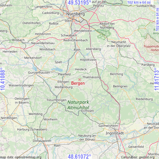
Bergen GPS coordinates[2]
49° 4' 24.492" North, 11° 6' 50.4" East
| Map corner | latitude | longitude |
|---|---|---|
| Upper-left | 49.53195°, | 10.41088° |
| Center: | 49.07347°, | 11.114° |
| Lower-right: | 48.61072°, | 11.81713° |
| Map W x H: | 102.4×102.4 km | = 63.6×63.6mi |
| max Lat: | 55.01917° ⇑82.1% North |
| Bergen: | 49.07347° |
| min Lat: | ⇓17.9% South 47.40724° |
| min Long | Bergen | max Long |
| 5.92978° | 11.114° | 14.98853° |
| W 68.6%⇐ | ⇒31.4% E |
Elevation
Elevation of Bergen is 540 m = 1772 ft, and this is 290.9 m = 954 ft above average elevation for this country.
| Max E: |
1256 m = 4121 ft | 8.2% |
| Bergen | 540 m 1772 ft | |
| Avg. | 249.1 m = 817 ft | |
Min E: |
-5 m = -16 ft | 91.8% |
See also: Germany elevation on elevation.city.
Geographical zone
Bergen is located in North temperate zone (between Tropic of Cancer and the Arctic Circle). Distance of this North polar circle is 1944.7 km =1208.4 mi to North.| Distance of | km | miles | from Bergen |
|---|---|---|---|
| North Pole | 4550.6 | 2827.6 | to North |
| Arctic Circle | 1944.7 | 1208.4 | to North |
| Tropic Cancer | 2850.5 | 1771.2 | to South |
| Equator | 5456.5 | 3390.5 | to South |


Nearby cities:
15 places around Bergen: (largest is in red/bold)
• Burgsalach
4.6 km =2.9 mi,  194°
194°
• Ellingen
10.7 km =6.6 mi,  262°
262°
• Ettenstatt
4.3 km =2.7 mi,  276°
276°
• Georgensgmünd
14.7 km =9.1 mi,  331°
331°
• Greding
17.9 km =11.1 mi,  99°
99°
• Heideck
6.8 km =4.2 mi,  8°
8°
• Hilpoltstein
14.2 km =8.8 mi,  23°
23°
• Höttingen
8 km =5 mi, 261°
• Nennslingen
3.2 km =2 mi,  157°
157°
• Pleinfeld
10.2 km =6.3 mi,  289°
289°
• Pollenfeld
15.1 km =9.4 mi, 155°
• Raitenbuch
6.6 km =4.1 mi,  173°
173°
• Röttenbach
10.3 km =6.4 mi, 325°
• Thalmässing
8 km =5 mi,  78°
78°
• Weißenburg in Bayern
11.4 km =7.1 mi,  245°
245°
Sources, notices
• [Note1] Compared only with cities in Germany existing in our database
• [Src1] Map data: © OpenStreetMap contributors (CC-BY-SA)
• [Src2] Other city data from geonames.org with taken over terms of usage.
• [Src3] Geographical zone / Annual Mean Temperature by Robert A. Rohde @ Wikipedia
