Ettenstatt geodata
Ettenstatt (Bavaria) is a seat of a fourth-order administrative division; located in Germany in Europe/Berlin (GMT+2) time zone. With population of 842 people, there are 7733 cities with bigger population in this country. Compared to other cities in Germany, 82% of cities are located further ↑North; 67.7% of cities are located further ←West and 81.9% of cities have lower elevation than Ettenstatt. Note1
Administrative division(s):
- Level 1: Bavaria
- Level 2: Regierungsbezirk Mittelfranken
- Level 3: Landkreis Weißenburg-Gunzenhausen
- Level 4: Ettenstatt


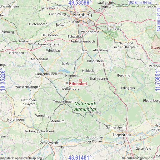
Ettenstatt GPS coordinates[2]
49° 4' 39.072" North, 11° 3' 19.368" East
| Map corner | latitude | longitude |
|---|---|---|
| Upper-left | 49.53596°, | 10.35226° |
| Center: | 49.07752°, | 11.05538° |
| Lower-right: | 48.61481°, | 11.75851° |
| Map W x H: | 102.4×102.4 km | = 63.6×63.6mi |
| max Lat: | 55.01917° ⇑82% North |
| Ettenstatt: | 49.07752° |
| min Lat: | ⇓18% South 47.40724° |
| min Long | Ettenstatt | max Long |
| 5.92978° | 11.05538° | 14.98853° |
| W 67.7%⇐ | ⇒32.3% E |
Elevation
Elevation of Ettenstatt is 445 m = 1460 ft, and this is 195.9 m = 643 ft above average elevation for this country.
| Max E: |
1256 m = 4121 ft | 18.1% |
| Ettenstatt | 445 m 1460 ft | |
| Avg. | 249.1 m = 817 ft | |
Min E: |
-5 m = -16 ft | 81.9% |
See also: Germany elevation on elevation.city.
Geographical zone
Ettenstatt is located in North temperate zone (between Tropic of Cancer and the Arctic Circle). Distance of this North polar circle is 1944.3 km =1208.1 mi to North.| Distance of | km | miles | from Ettenstatt |
|---|---|---|---|
| North Pole | 4550.2 | 2827.4 | to North |
| Arctic Circle | 1944.3 | 1208.1 | to North |
| Tropic Cancer | 2851 | 1771.5 | to South |
| Equator | 5456.9 | 3390.8 | to South |


Nearby cities:
15 places around Ettenstatt: (largest is in red/bold)
• Absberg
14.7 km =9.1 mi,  300°
300°
• Alesheim
14.3 km =8.9 mi,  256°
256°
• Bergen
4.3 km =2.7 mi,  96°
96°
• Burgsalach
5.8 km =3.6 mi,  148°
148°
• Ellingen
6.6 km =4.1 mi,  253°
253°
• Georgensgmünd
12.8 km =8 mi,  347°
347°
• Heideck
8.1 km =5 mi,  39°
39°
• Höttingen
4 km =2.5 mi, 245°
• Nennslingen
6.4 km =4 mi,  121°
121°
• Pleinfeld
6.1 km =3.8 mi, 299°
• Raitenbuch
8.6 km =5.3 mi,  144°
144°
• Röttenbach
8.2 km =5.1 mi, 348°
• Spalt
14.5 km =9 mi,  318°
318°
• Thalmässing
12.2 km =7.6 mi,  84°
84°
• Weißenburg in Bayern
8 km =5 mi,  229°
229°
Sources, notices
• [Note1] Compared only with cities in Germany existing in our database
• [Src1] Map data: © OpenStreetMap contributors (CC-BY-SA)
• [Src2] Other city data from geonames.org with taken over terms of usage.
• [Src3] Geographical zone / Annual Mean Temperature by Robert A. Rohde @ Wikipedia
